
131 Haverhill Road - Resource Area Delineation
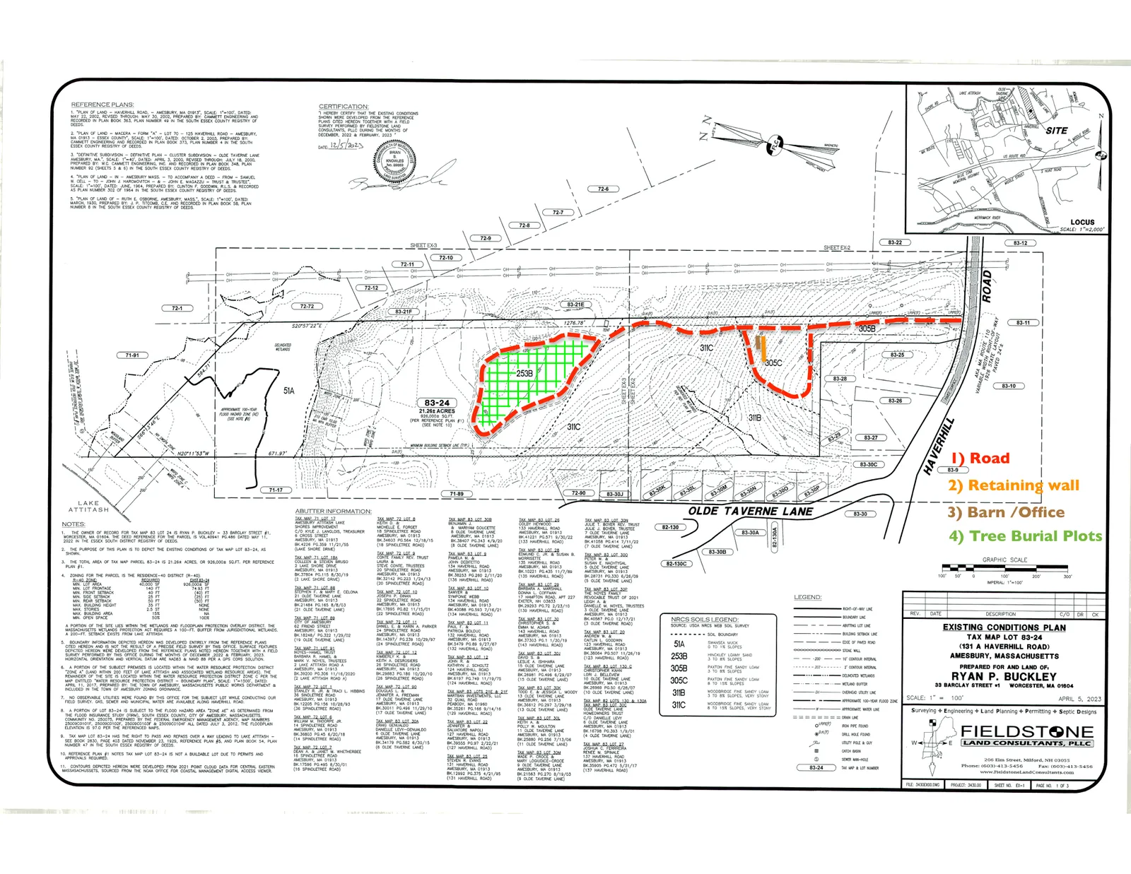
Phase I materials propose a 24' gravel access road system, a 40' retaining wall, a 16×20 barn/office, and tree burial plots on a 2.1268‑acre parcel at 131A Haverhill Road.

AI summary
Phase I materials for 131A Haverhill Road (Tax Map Lot 83‑24) propose a 24' wide gravel access road and loop, a 40'×2'×6' concrete block retaining wall, a 16×20 barn/office, and tree burial plots beneath native trees on a 2.1268‑acre parcel. Portions of the site are in the Town Water Resource Protection District and FEMA Zone AE; wetlands, buffer, and floodplain considerations may require Conservation Commission permits (for example, an Order of Conditions) and additional engineered submissions in later phases.
Gallery
Project details
What is proposed
The applicant, Ryan P. Buckley, submitted Phase I materials describing four primary elements for the property at 131A Haverhill Road (Tax Map Lot 83‑24): a new vehicular access road and loop system, a retaining wall, a small barn/office building, and a program of tree burial plots with expanded walking trails. The materials are filed with the Amesbury Conservation Commission as an "Other" application and identify this work as the first phase of a multi‑phase plan.
The submission specifies construction materials and dimensions for the retaining wall and barn, describes the road width and surfacing, and explains the proposed burial method (aquamation) and plot layout. The applicant indicates further engineered plans (for example, a detailed driveway/approach plan) will be provided in subsequent phases.
Where and how big
The plan identifies the parcel area as 2.1268 acres. The map and existing‑conditions survey show property boundaries, topographic contours, wetland locations, flood zone delineations, soil mapping (noting Paxton fine sandy loam in portions of the site), and adjacent rights‑of‑way. The parcel is located in the Residence 40 (R‑40) zoning district.
Environmental overlays affecting the site include the Town’s Water Resource Protection District (portions mapped as Zone A—land within 200 feet of Lake Attitash—and Zone C) and a portion of the lot within FEMA Flood Hazard Area Zone AE. The plan also highlights the 100‑foot buffer requirement under the Massachusetts Wetlands Protection Act where jurisdictional wetlands are present.
Parking, access and transportation
Phase I proposes a 24‑foot wide gravel access road system intended to provide ingress and egress for personal and emergency vehicles and to connect the higher and lower elevations of the parcel. The road is described to become a one‑way loop on the upper portion, following existing walking paths, with an upper loop that includes a U‑turn located approximately 250 feet from the east property line. All on‑site roads are specified as gravel to promote surface drainage.
The existing entrance on Haverhill Road would be reused for personal access with no alterations in Phase I. The applicant states a detailed engineered driveway approach plan will be submitted in Phase II by Fieldstone Land Consultants to address MassDOT vehicular access permitting requirements. The Phase I materials do not list a specific number of paved parking spaces or a paved parking area.
Special considerations and construction details
Retaining wall: The plan shows a proposed retaining wall 40 feet long × 2 feet wide × 6 feet tall. Construction details in the submission include use of concrete block units (4×2×2 concrete block molds), a 10‑inch foundation trench with compact Portland Type S base, two layers of geogrid, 10 inches of compacted 3/4" clean stone under the wall, and a drainage system with backfill of 3/4" clean stone.
Barn / office: A 16×20 foot barn/office is proposed on a poured concrete slab, with 2×6 wall framing, a 2×10 gambrel roof structure, a 6‑foot roof overhang, and an internal loft. The plan shows the building located well within the parcel interior; distances from Route 110 and property lines are noted on the drawing.
Tree burial plots and aquamation: The applicant proposes tree burial plots described as roughly 100 square feet per plot. The materials indicate each plot would contain up to seven biodegradable human remains placed beneath a native dwarf flowering tree. The applicant describes the preferred disposition method as aquamation (also called alkaline hydrolysis), a water‑based process for reducing human remains. The submission states that burials would avoid use of metal or heavily varnished caskets, concrete vaults, embalming fluids (e.g., formaldehyde), and traditional headstones, and that walking paths would be expanded to provide access around burial areas.
Wetland and floodplain implications: The plan maps jurisdictional wetlands, the 100‑foot wetland buffer required under the Massachusetts Wetlands Protection Act, the Water Resource Protection District boundaries, and FEMA Zone AE floodplain limits. Work within jurisdictional areas or their buffers may require permits or an Order of Conditions from the Conservation Commission; an Order of Conditions is the Commission’s permit under the Wetlands Protection Act that sets conditions for work affecting wetlands and buffer areas.
Vegetation and tree removal: The access roads are sited to follow existing paths and clearings where practical, with the stated intent to preserve trees and vegetation where possible; however, the materials acknowledge that some tree removal will be necessary to construct the roads and site elements.
Utilities and rights‑of‑way: The survey notes a legal right to pass and repass over a way leading toward Lake Attitash. Municipal gas, sewer, and water are reported as available along Haverhill Road; the field survey did not identify utilities on the subject lot itself.
Status and next steps
Materials on file include an existing‑conditions survey and a Phase I scope/drawing prepared for the applicant. These materials document the applicant’s proposed layout, construction methods, and dimensions but do not constitute municipal approval.
Next steps identified in the submission and typical municipal process steps include submission of engineered plans (for example, a MassDOT‑compatible driveway approach plan in Phase II), staff review by the Conservation Commission, and determination of what permits or approvals are required. If work is found to be within jurisdictional wetlands or their buffer, the Conservation Commission may require a Notice of Intent and issue an Order of Conditions (a wetlands permit) that would set terms and conditions for permitted work. Other potential permits could include MassDOT driveway permitting or other local or state approvals depending on scope and location of work.
The Conservation Commission and other municipal departments will review the submitted materials and request additional information or revisions as needed as part of the permitting process.
Discussion at meetings
- APPROVEI will accept as moved from Commissioner McCarthy a motion to accept the ANRAD.
- CONTINUESo moved.
- CONTINUEDo I have a motion to continue?
- CONTINUEI'll entertain a motion to continue this until November.
- CONTINUEI would move that we continue this hearing until next month's meeting.
- CONTINUEContinue ANRAD — 131 Haverhill Road to September 2nd
- APPROVEWell, I'll move that we accept the Goddard quote.
- OTHERA motion to approve a peer review of the wetland delineation for 131 Haverhill Road.


