
30 Lake Attitash Road - Amendment
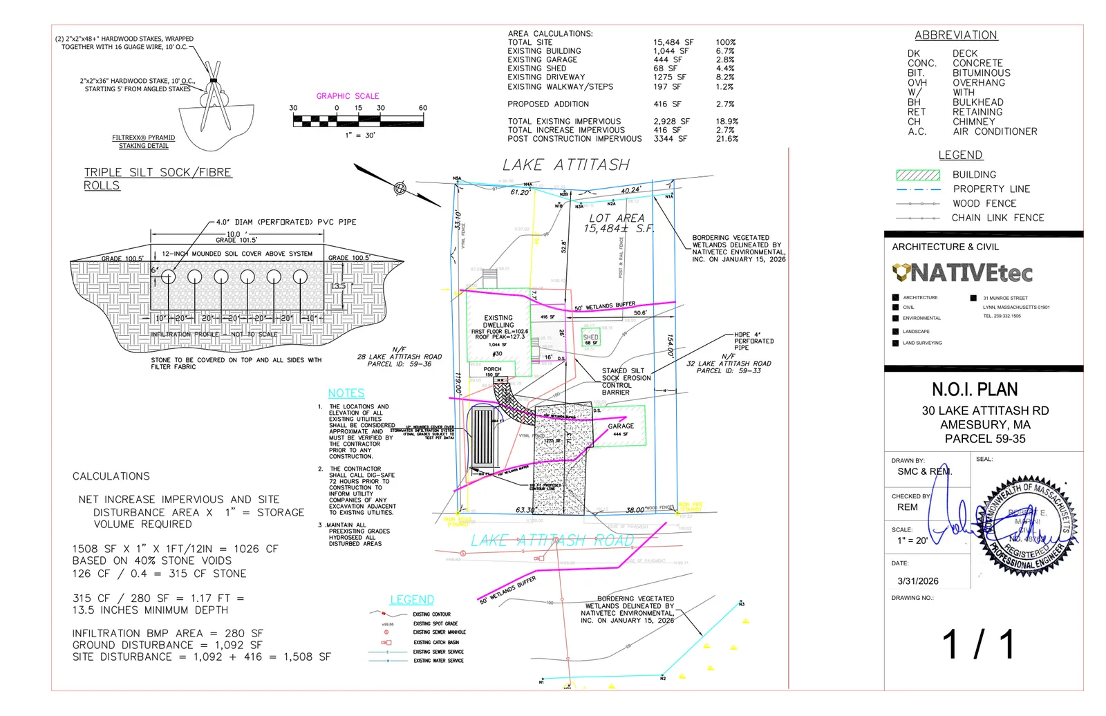
A single‑family house addition is proposed at 30 Lake Attitash Road; site plans show a 416 sq ft footprint increase with related erosion control and an infiltration BMP, and filings include a Planning Board Special Permit and a Conservation Commission amendment.

AI summary
An addition is proposed to the single‑family house at 30 Lake Attitash Road; plan drawings show a 416 sq ft footprint addition (16' x 26') while a Planning Board form describes the work in text as approximately 1,000 sq ft. The site plan and erosion control materials document disturbance limits, an infiltration BMP, mapped wetlands and a 50‑ft buffer, and filings include a Conservation Commission amendment and a Planning Board Water Resource Protection District Special Permit application.
Gallery
Project details
What is proposed
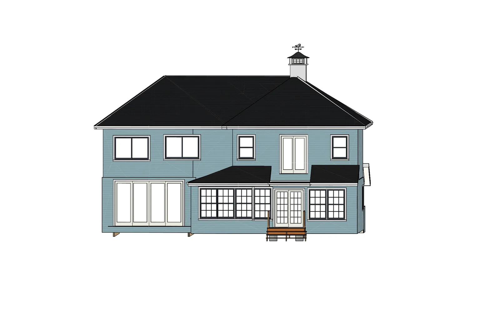
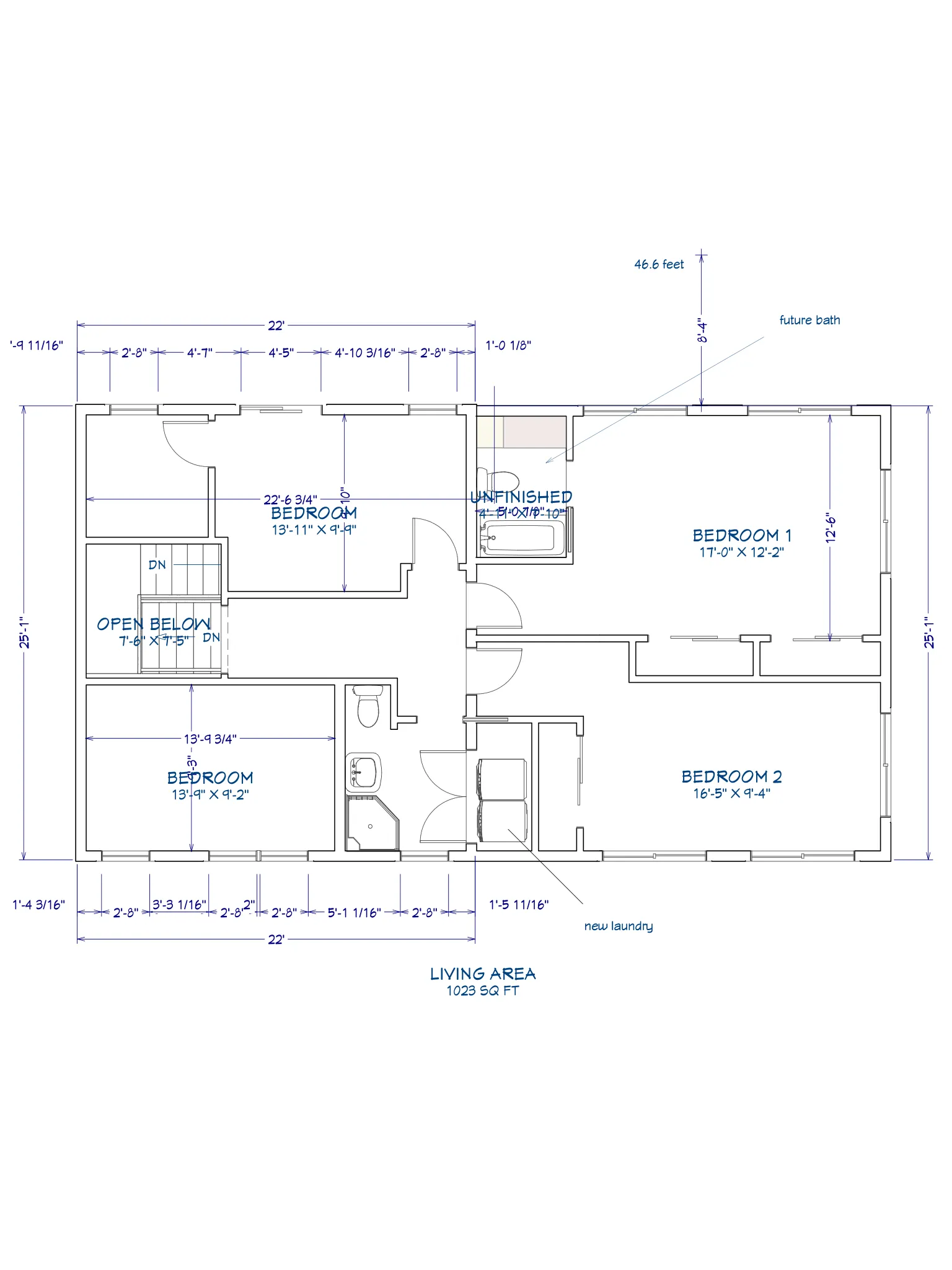
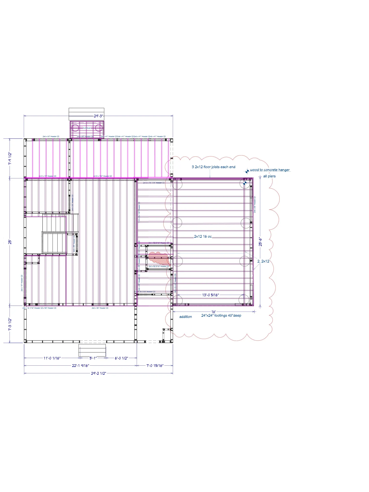
The project proposes an expansion of an existing single‑family residence at 30 Lake Attitash Road. Application materials describe an addition that will add living space: plan sheets show a 416 square‑foot footprint addition (labeled as a 16' x 26' addition) and the Planning Board Special Permit form describes the work in text as roughly a 1,000 square‑foot addition. The filing materials include floor plans showing interior layouts: the first floor addition area is shown to provide a living room, pantry and closet, and the second floor layout indicates two bedrooms and one full bathroom in the added area.
Where and how big
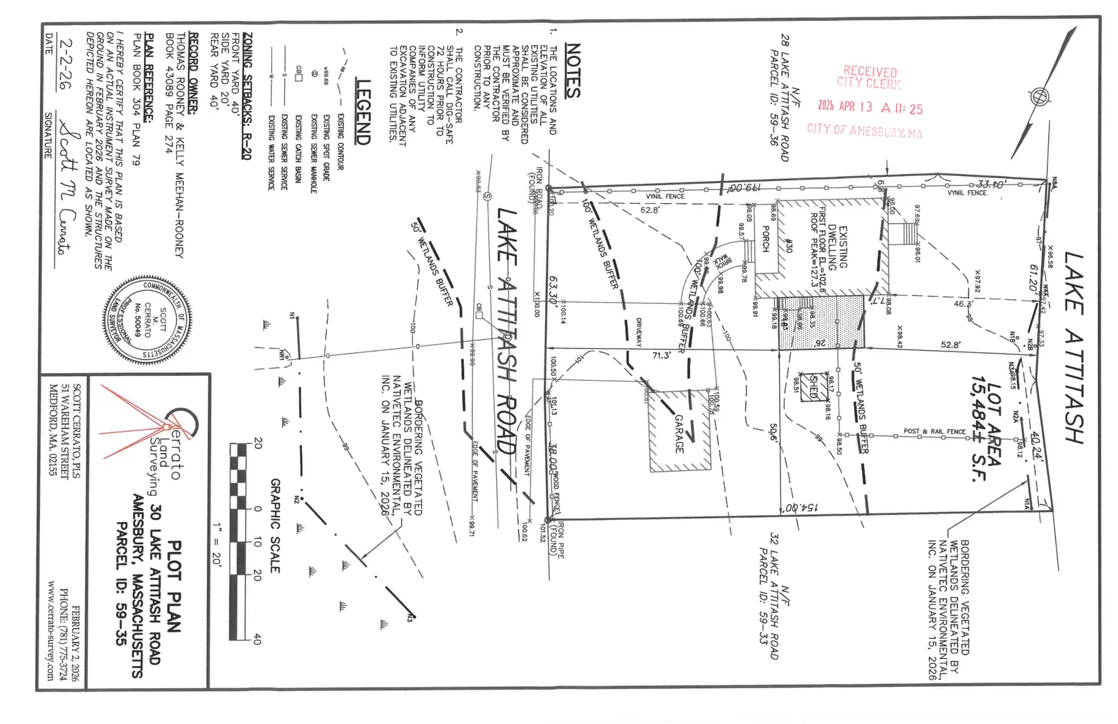
The property is shown on the February 2026 survey and site plan with a lot area of 15,484 square feet; the Special Permit form lists the lot as 15,246 square feet. The site plan documents existing site features and areas: the principal building is shown as 1,044 sq ft, the garage 444 sq ft, a shed 68 sq ft, and an existing driveway of 1,275 sq ft. The erosion control/area calculations list total existing impervious surface at 2,928 sq ft (18.9% of the lot) and post‑construction impervious surface at 3,344 sq ft (about 21.6%). The plans therefore report a net impervious increase of 416 sq ft associated with the proposed addition.
Construction and erosion control
Construction drawings include foundation and framing details for the addition, including 24" x 24" footings at 48" depth and typical header and joist schedules (examples shown: 2x6 and 2x10 members and I‑joists at 16" on center). The erosion control plan identifies standard measures to limit sediment transport during construction, such as staked silt socks (fiber rolls), staked erosion control barriers, and inlet protection. Calculations in the plan indicate ground disturbance of 1,092 sq ft and total site disturbance of 1,508 sq ft (this includes the addition plus disturbed areas). An infiltration Best Management Practice (BMP) is shown with an infiltration area of 280 sq ft; the plan calculates required stone storage (315 cubic feet) and specifies a minimum depth for the system (shown as 13.5 inches minimum in the submitted calculations). The plan notes that contractors must verify utility locations and call DigSafe 72 hours before construction.
Wetlands, buffers and permits
The site plan maps bordering vegetated wetlands on or adjacent to the property and shows a 50‑foot wetlands buffer line. The wetlands were delineated on the plans by Nativetec Environmental, Inc. on January 15, 2026. The project record includes an amendment filing with the Conservation Commission; the Conservation Commission is the municipal board that reviews work in wetlands or their buffer zones. A typical Conservation Commission permit is an "Order of Conditions" — this is the Commission’s wetlands permit that authorizes work within jurisdictional areas and sets conditions to avoid, minimize or mitigate impacts. The materials on file also include a Planning Board application for a Water Resource Protection District Special Permit (filed March 18, 2026), which is a zoning review related to protected water resource areas.
Access, parking and site features
The plans do not show a new driveway or new dedicated parking area; the existing driveway and site features (walkway/steps, garage, shed, and utility service locations) are shown on the survey and site drawings. The survey and plan notes make clear that locations and elevations of existing utilities are approximate and must be verified by the contractor prior to construction.
Status and next steps
Documents on file include a stamped site survey dated February 2, 2026; an erosion control and site plan with calculations and BMP details; structural and floor plan drawings for the addition; a Planning Board Special Permit application received March 18, 2026; and an abutters list request submitted March 17, 2026 (for Conservation Commission use). The project is recorded as a Conservation Commission application amendment and as a Planning Board Water Resource Protection District Special Permit application. Next procedural steps for the applicant typically include formal review by the Conservation Commission (to determine whether an Order of Conditions or an amendment to an existing Order is required), Planning Board review of the Water Resource Protection District Special Permit, and contractor verification of utilities and final plan details before construction begins.
If you would like, I can extract and list the specific plan sheets and their key callouts (site plan, erosion control, floor plans, elevations), or prepare a plain‑language FAQ describing what typically happens at a Conservation Commission hearing and what residents might expect to see on plan sheets.
Discussion at meetings
- APPROVEIssue an Order of Conditions for NOI 002-1366 (30 Lake Attitash Road) with required best management practices and invasive knotweed management.
- APPROVESo moved.
- OTHERI'm willing to accept the modification as long as the proposed mitigation plan is implemented.
- APPROVEI move to acknowledge and approve the emergency certificate.
Documents on file


