
80 Haverhill Rd - Modification
Renovation of the historic house at 80 Haverhill Road plus a new barn‑style building to create a total of eight residential units, approved by the Planning Board on February 24, 2025.

AI summary
The project at 80 Haverhill Road would rehabilitate the existing historic house and construct a new barn‑style building to increase the property from four to eight residential units, with a proposed total gross floor area reported near 10,771 sf. The Planning Board approved Site Plan Review and a Historic Preservation Special Permit on February 24, 2025; site plans show 16 parking spaces, municipal utility connections, and a stormwater system using proprietary separators and subsurface infiltration chambers. A Preservation Restriction will be placed on the historic house and the project must follow the conditions and technical plans included in the Board’s Decision.
Gallery
Project details
What is proposed
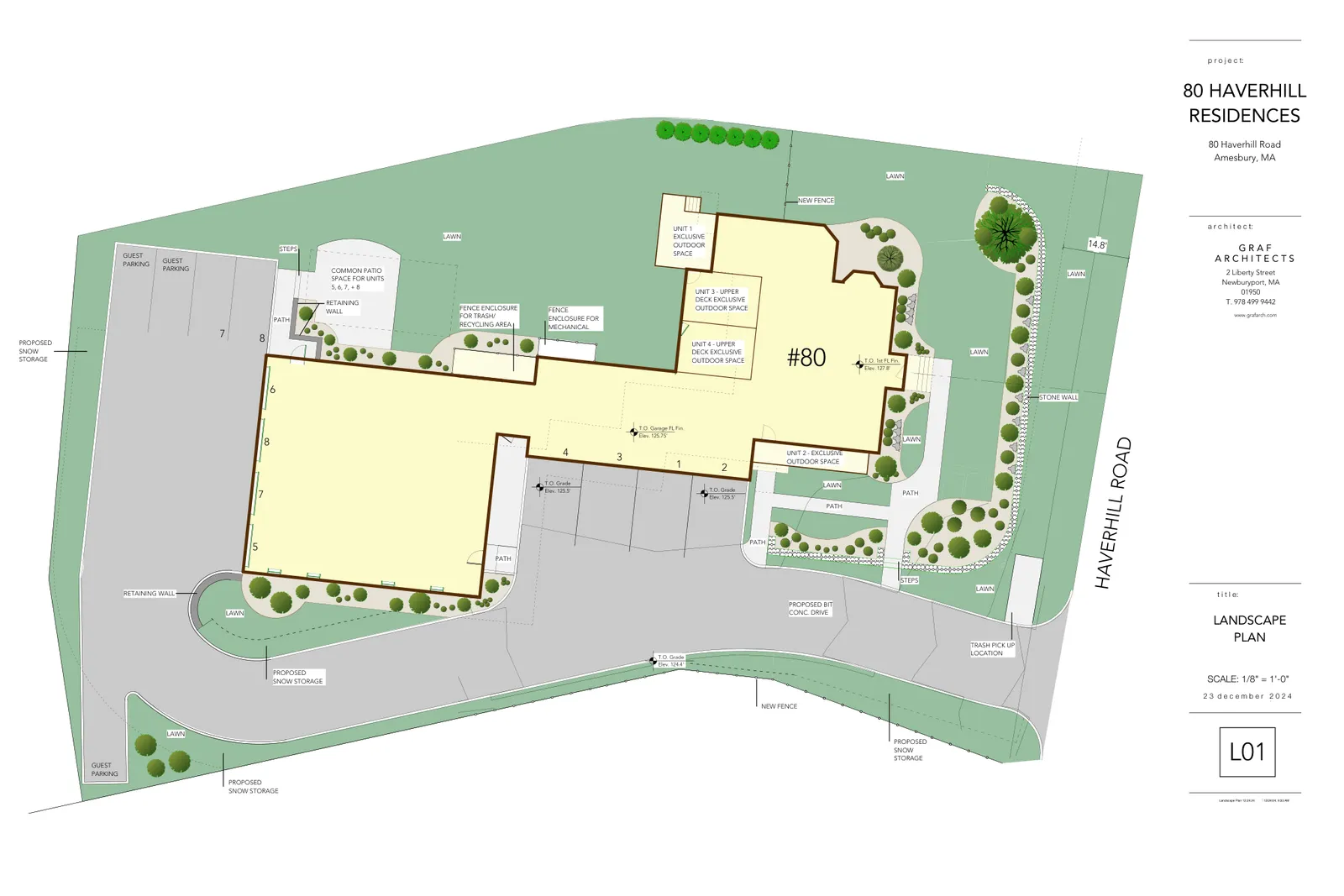
The project would rehabilitate the existing historic residence at 80 Haverhill Road and construct a new, barn‑style residential building on the same parcel. The existing historic house will continue to contain four dwelling units; the new barn building will add four additional units for a total of eight units on the property.
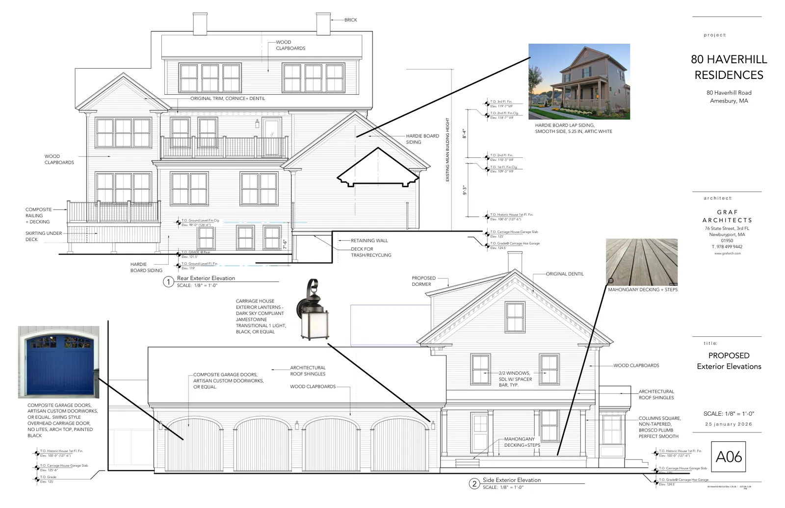
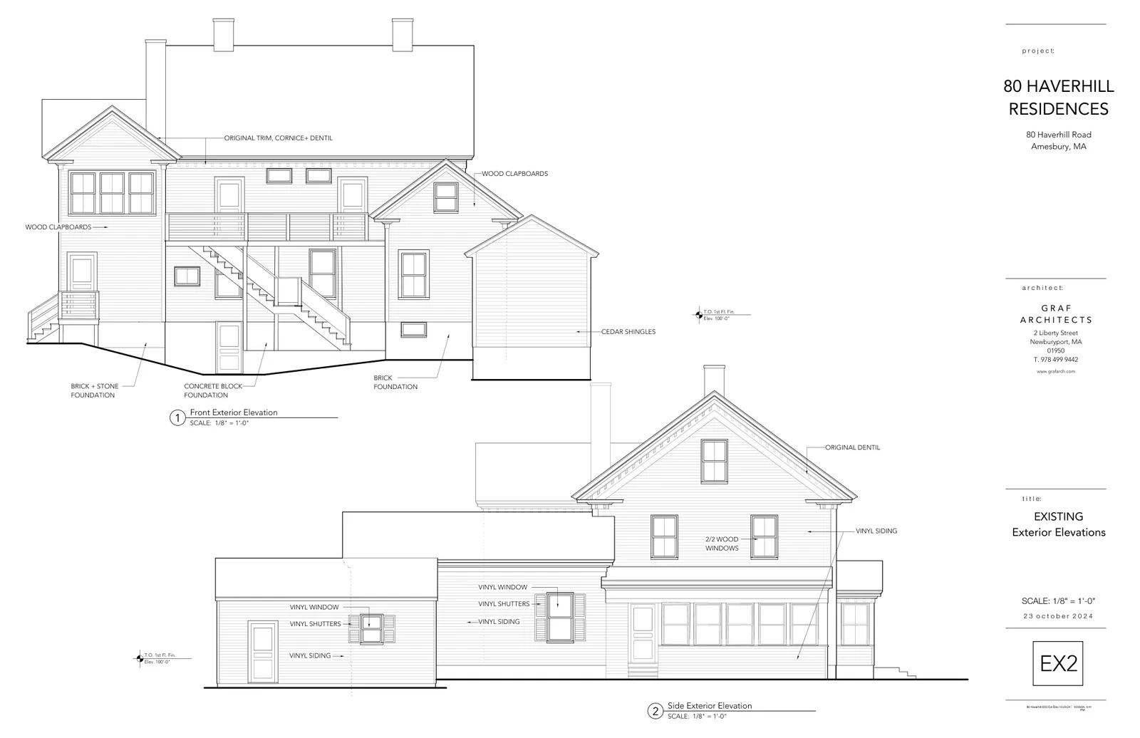
Exterior work on the historic house includes restoring identified historic elements (for example, corner boards and dentil work), rebuilding the two main chimneys above the roof, replacing non‑historic vinyl siding with natural siding or wood clapboards, and replacing mismatched vinyl windows with 2/2 simulated divided‑light windows. A dormer is proposed at the rear of the house as shown on the architectural drawings.
Where and how big
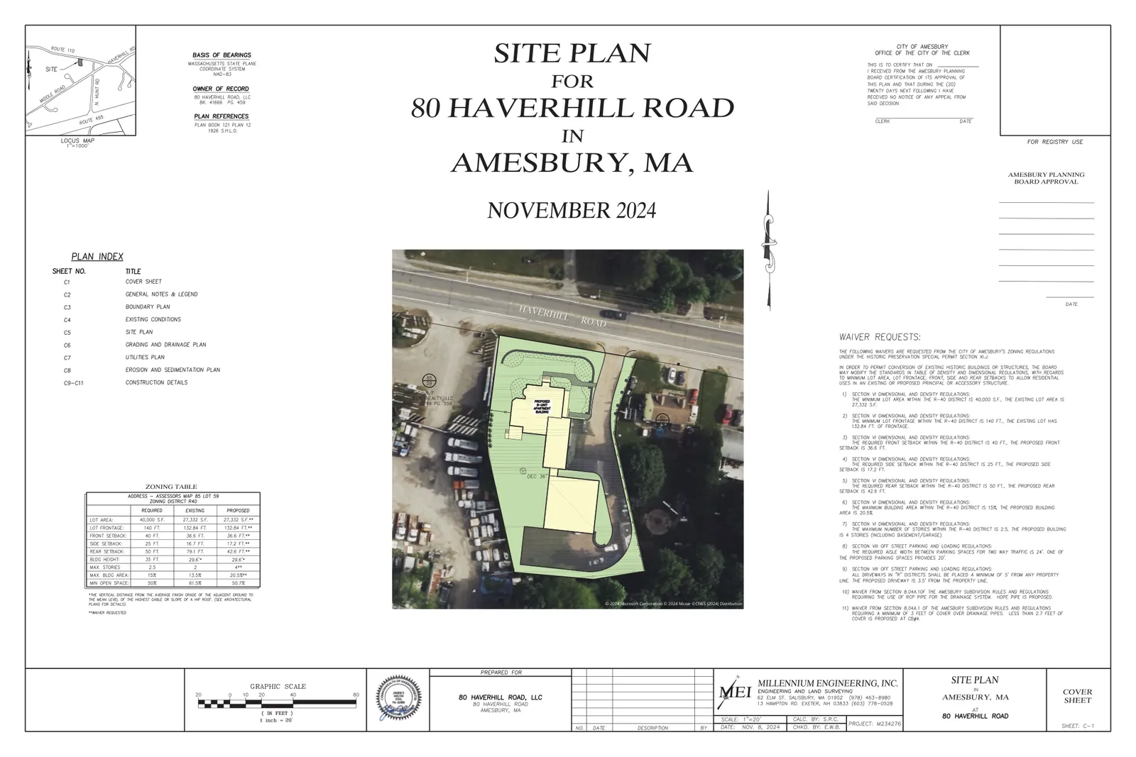
The property is identified as Assessors Map 85, Lot 59 and is located in the R‑40 zoning district of Amesbury. The Planning Board decision describes the parcel as approximately 27,332 square feet; some engineering documents used for stormwater analysis reference a similar figure of about 23,332 square feet. The Special Permit application lists an existing gross floor area near 4,661 square feet and a proposed gross floor area near 10,771 square feet.
Architectural plans include floor plans and SF calculations. Units shown in the historic house have total areas of roughly 1,030–1,301 square feet each (per plan labels). Units in the proposed barn are larger, with plan totals in the range of about 1,430–1,567 square feet each. The new barn footprint is located roughly where a previous barn stood and will be connected to the historic house via the rear covered/parking area shown on the plans.
Parking, access and transportation
The plan retains the existing driveway location on Haverhill Road and shows an improved 18‑foot‑wide driveway serving the site. The approved site plan provides 16 parking spaces in total, including four covered garage/carriage‑house spaces within the new barn structure and additional at‑grade parking behind and adjacent to the covered spaces. The site plan also identifies guest parking and areas for snow storage.
Utility work indicated in the engineering materials shows proposed connections to municipal water and sewer mains on Haverhill Road, and underground electrical and telecommunications service. Trash/recycling and mechanical equipment locations are shown on the landscape and site plans and are indicated to be fenced or screened.
Stormwater, drainage and other site controls (special considerations)
Civil engineering and stormwater reports prepared for the project analyze pre‑ and post‑development runoff and propose a stormwater management system consisting of catch basins, Contech CDS proprietary water‑quality separators, subsurface infiltration chambers, and roof drywells. The submitted Hydrologic/HydroCAD modeling evaluated the 2‑, 10‑ and 100‑year storm events and the design was prepared to meet applicable Massachusetts stormwater standards. The stormwater report shows that the proposed infiltration systems provide substantially more recharge capacity than the calculated required recharge volume, and includes drawdown and TSS (total suspended solids) calculations.
The stormwater materials include a Long‑Term Operation & Maintenance plan for the stormwater features and a Construction Period Erosion and Sedimentation Control plan. The Planning Board’s decision notes that the stormwater engineering was reviewed by the Board’s peer reviewer and found acceptable, and that the project’s stormwater controls must be installed per the approved plans and conditions of approval.
(Technical note: a Preservation Restriction is a recorded legal covenant that limits future changes to identified historic features; a Site Plan Review is a municipal review process that evaluates site layout, drainage, access and related infrastructure; a Historic Preservation Special Permit is the zoning permit that allows modifications and reuse of a historic structure subject to conditions in the zoning bylaw.)
Historic preservation features
The Amesbury Historical Commission reviewed the proposal and deemed the existing house historically significant. The Planning Board decision and application materials indicate that a Preservation Restriction will be placed on the historic house to protect its identified significant features. The Planning Board’s approval specifies restoration or replacement of particular exterior elements (for example, restoring original trim, cornice and dentil work, replacing non‑historic siding and windows with materials and profiles shown on the approved drawings).
The Decision also states that if changes are proposed beyond those approved by the Board, additional review and approval by the Historical Commission may be required. The Preservation Restriction and the approved architectural drawings together define the historic protections to be recorded and implemented.
Status and next steps
The Planning Board opened the public hearing on December 9, 2024, closed the hearing on February 24, 2025, and issued a written Decision on February 24, 2025 granting Site Plan Approval and a Historic Preservation Special Permit subject to the conditions and design performance standards in that Decision. The Decision lists the plan set and supporting documents that constitute the approved project.
Typical next steps following Planning Board approval include: recording the Preservation Restriction and any required easements, obtaining building permits, satisfying any pre‑construction conditions in the Planning Board Decision (for example final engineering or easements, if required), and implementing the construction‑period erosion controls and the approved stormwater systems. The Planning Board Decision also notes that other municipal approvals may be needed if the project scope changes from what was approved or if separate permits are required by other City boards or commissions.
Discussion at meetings
- APPROVEApprove the Construction Management and Mitigation Plan (CMMP) for 80 Haverhill Rd
- APPROVEDetermine the applicant's requested change to the historic-preservation special permit at 80 Haverhill Road is a minor modification and approve the modification to increase the unit count from 4 to 7 without changing the approved building footprint.
- APPROVEApprove decision dated 2/24/25 for the site plan and special permit at 80 Haverhill Rd. with the edit on page 12 in section 14.
- OTHERPascal Rettig motioned to ask staff to draft a decision for 80 Haverhill Road.
- OTHERUse Stantec for a peer review of the storm water design and calculations.
Documents on file


