
37 Clarks Road - Site Plan Review
Site Plan approval was granted July 29, 2024 to replace the former Friendly’s at 37 Clark’s Road with a ~2,400 sf Starbucks coffee shop with drive‑through, subject to site, stormwater, traffic, landscaping, signage and construction conditions.

AI summary
Amesbury Lodging Ventures LLC received Planning Board Site Plan approval (July 29, 2024) to demolish the former Friendly’s at 37 Clark’s Road and construct a Starbucks coffee shop with a drive‑through on the existing ~2.99‑acre parcel. The project includes a ~2,400 sf coffee shop (34 seats), on‑site parking for 128 vehicles (combined site), stormwater controls (infiltration basin), sidewalks, and a drive‑through sized for a 15‑car queue; approval is conditional on completing stormwater installations, posting erosion‑control surety, implementing off‑site signal timing/coordination for Route 110, DPW coordination for right‑of‑way work, and submitting certified as‑built plans prior to occupancy.
Gallery
Project details
What is proposed
A Site Plan Review application by Amesbury Lodging Ventures LLC proposes to demolish the vacant Friendly’s restaurant on the parcel at 37 Clark’s Road and construct a single‑story Starbucks coffee shop with a drive‑through. The proposed building area is shown in the plan set as about 2,374 square feet, while the Transportation Impact Assessment references approximately 2,460± square feet; the design includes indoor seating (34 seats noted in the TIA), outdoor seating, a drive‑through lane, customer parking, and support features such as a trash enclosure.
Where and how big
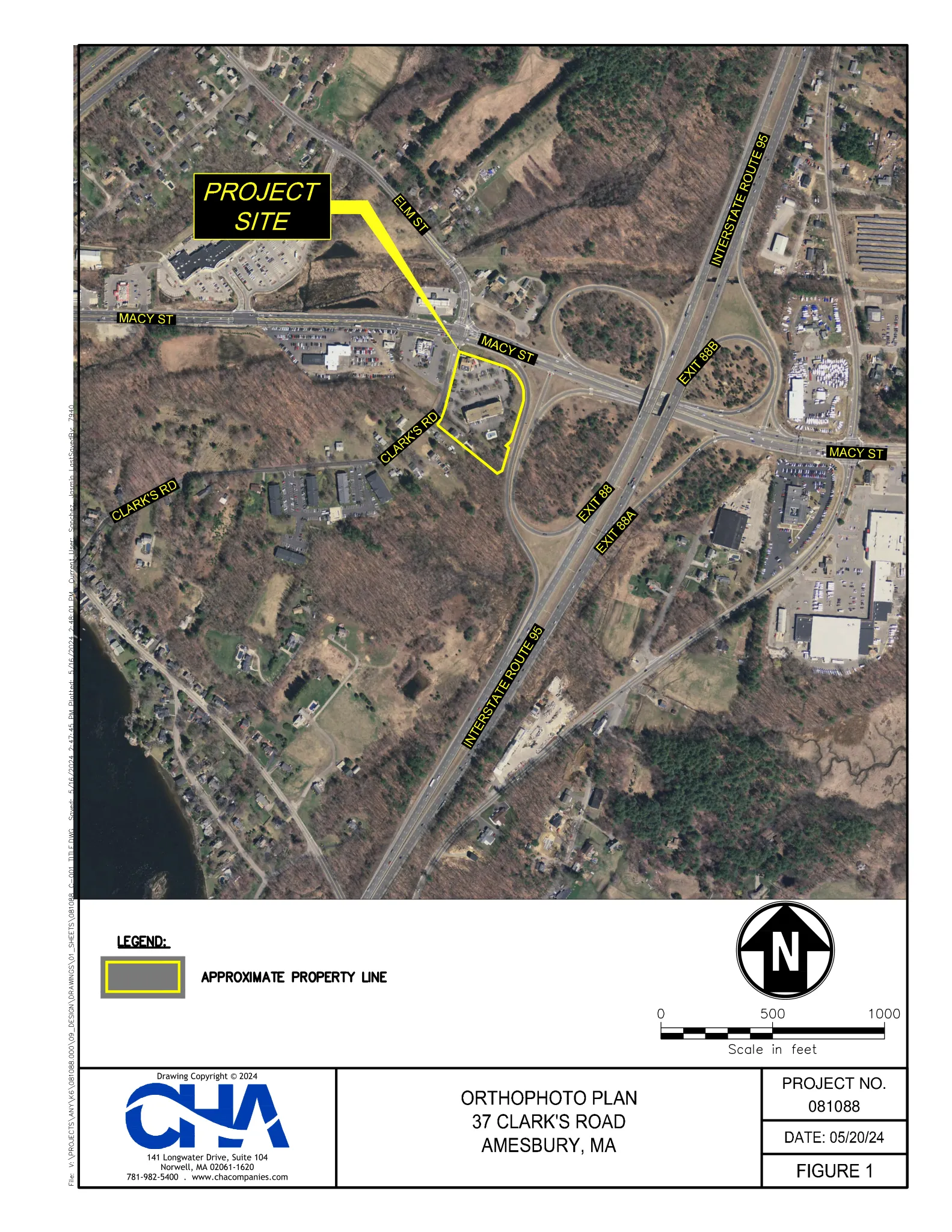
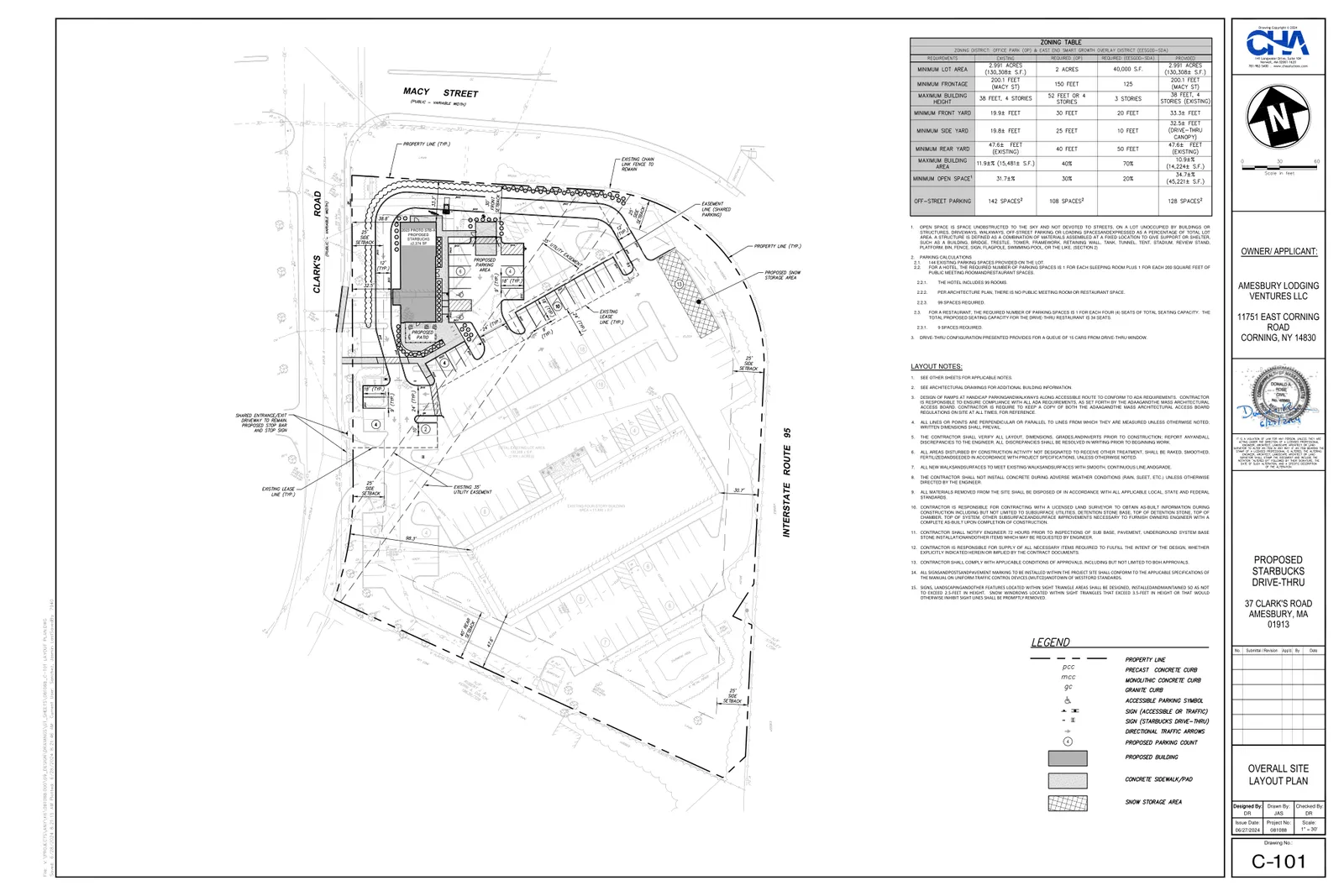
The project is on a parcel shown as approximately 130,308 square feet (about 2.991 acres) at 37 Clark’s Road (Assessor Map 80 / Lot 18). The existing parcel contains a Fairfield Inn (existing four‑story building shown at ~11,850 sf) and the former Friendly’s restaurant to be removed. The site plans locate the new coffee shop and drive‑through in the area formerly used for the restaurant and its parking, and show stormwater infrastructure, snow storage areas, and landscaping beds.
Parking, access and transportation
On‑site parking and circulation: The combined site plan (hotel plus coffee shop) provides 128 parking spaces. The zoning calculation in the submitted materials shows 108 spaces are required (99 spaces for the hotel usage plus the coffee shop parking requirement based on seating). Drive aisles and parking are dimensioned to accommodate maneuvering; the drive‑through is sized to accommodate a queue of up to 15 vehicles at the window.
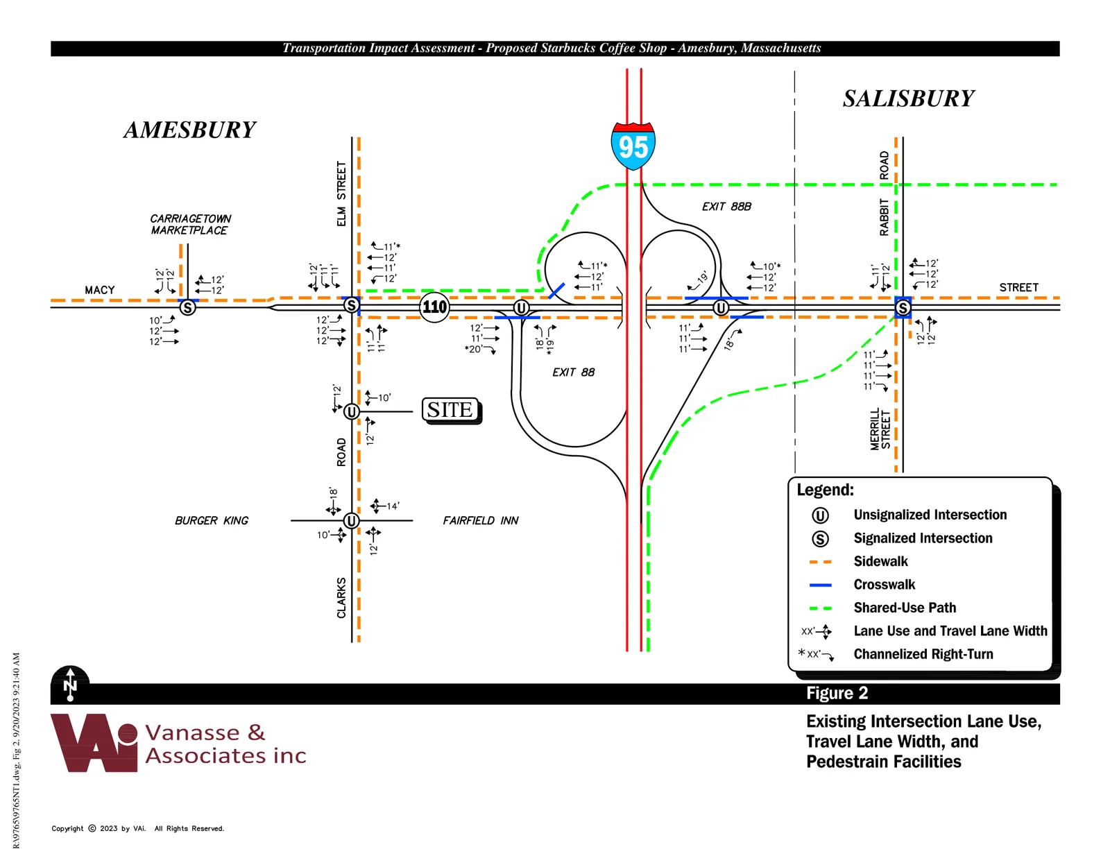
Access and off‑site work: Vehicular access is proposed via the existing southern shared driveway to Clark’s Road; the existing northern driveway serving the site is proposed to be closed. The Transportation Impact Assessment (TIA) evaluated existing and future traffic and recommended a set of mitigations. The Planning Board decision requires the applicant to modify the driveway alignment with Clark’s Road, coordinate any right‑of‑way work with the Department of Public Works (DPW), and to install vertical granite curbing in specified locations. The Board also requires implementation of updated signal timing/phasing and coordination for the Route 110 traffic signal system prior to Certificate of Occupancy to address peak hour operations (subject to permits and approvals).
Pedestrian and bicycle accommodations: The Board requires concrete sidewalks at least 5 feet wide and a sidewalk connection from the coffee shop to existing sidewalks along Clark’s Road/Route 110 where feasible. Marked crosswalks and ADA‑compliant ramps are required within the site. The Planning Board required the addition of one bicycle rack to the site plan.
Definitions: The Transportation Impact Assessment (TIA) is a traffic study that estimates vehicle trips generated by the proposed use, analyzes effects at nearby intersections, and recommends mitigation. A Certificate of Occupancy is the City document issued after construction is complete and approvals met, permitting building occupation.
Site features, stormwater, landscaping, lighting and building design
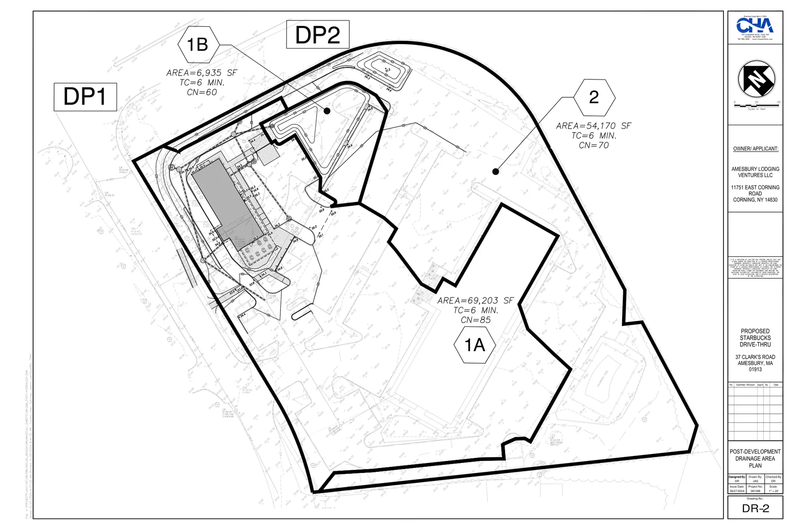
Stormwater and erosion control: The submitted site plans include catch basins and an infiltration basin with an outlet drain; a Stormwater Report and an Operation & Maintenance plan were submitted. The Planning Board requires completion and verification of all stormwater management improvements and a certified as‑built plan prior to requesting an occupancy permit. The Board also requires posting of a surety bond for sedimentation and erosion control to ensure that drainage and erosion control measures are implemented and that disturbed areas stabilize before release of the surety.
Landscaping and site details: The Board required additions and adjustments to the landscape plan, including salt‑tolerant grasses and shrubs in and around the drainage basin, a boxwood hedge along the drive‑through planted at 36 inches and maintained to a maximum of 42 inches at maturity, and the addition of four shade trees. Snow storage areas and a CMU trash enclosure are shown on the plans.
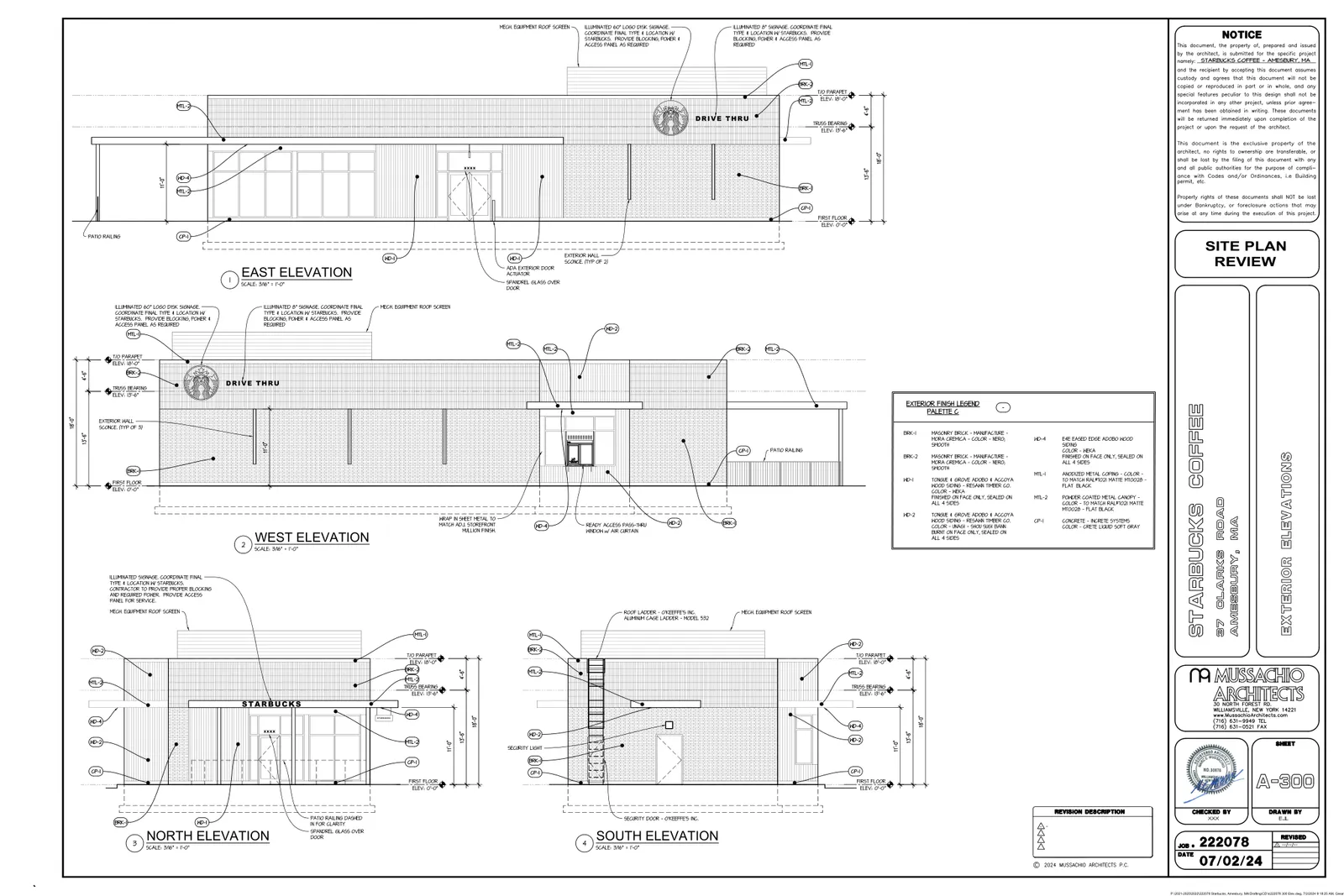
Lighting and signage: A photometric plan and luminaire schedule were submitted. The Board limited freestanding site light poles to a maximum height of 16 feet and required dark‑sky compliant fixtures. The Board required the removal of the existing free‑standing sign and requires either an additional wall sign on the north building wall or a landscaped trellis; final building materials and elevations must be submitted consistent with Design Review Committee or Planning Director approval.
Definitions: An "As‑Built Plan" is a post‑construction drawing certified by a registered professional showing how the project was actually built; a surety bond is a financial guarantee held by the municipality to ensure completion or correction of specified work.
Status and next steps
Planning Board action: The Amesbury Planning Board held a public hearing and issued a Final Decision approving the Site Plan on July 29, 2024. Approval is conditional; the Decision lists site‑specific and perpetual conditions that the applicant must meet.
Pre‑occupancy items and coordination: Key conditions to satisfy before occupancy include full installation and verification of stormwater systems, submission of a certified as‑built plan by a Massachusetts‑registered engineer or architect, posting of surety for sedimentation and erosion control, completion of required off‑site traffic signal timing/phasing and coordination work for the Route 110 signal system (subject to permits/agreements), coordination with DPW for any work in the Clark’s Road right‑of‑way, final building material selection consistent with design review approvals, and utility confirmation for adequate water and sewer flow for fire suppression and sanitation prior to building permit issuance.
What the Planning Board will review for final sign‑off: The Board will verify stabilization of disturbed areas, functioning stormwater management systems, required landscaping and site features installed per the approved plans, and receipt of required certifications prior to release of surety and to sign off on the as‑built plan and allow the City to issue a Certificate of Occupancy.
If you would like, the next page can present the Planning Board conditions as a simple checklist or extract the specific plan sheet numbers that show the stormwater basin, driveway revisions, and sidewalk locations.
Discussion at meetings
- APPROVEI make a motion that we approve the sign package as submitted and with the DRC's recommendation to approve so that was the revised sign package
- APPROVEI move that we approve the submitted sign with the updated bracket
- APPROVEDavid Frick motioned to approve the Site Plan Review application for 37 Clarks Road with the condition that the applicant satisfy outstanding comments from the Technical Review Committee and Design Review Committee and submit corresponding revised plans and memo summarizing the addressed comments. Seconded by Keith Ratner.
Documents on file


