
27.5-29 Clarks Road - Site Plan Review
Eagles Crossing proposes three residential buildings with 152 units, parking and a public trail/boardwalk on an ~11‑acre site at 27.5 & 29 Clarks Road; Planning Board issued a Site Plan decision on January 29, 2026, with conditions and outstanding conservation and technical items to resolve.

AI summary
Eagles Crossing LLC proposes a three‑building residential development at 27.5 & 29 Clarks Road with 152 units, about 203 parking spaces (including below‑grade parking), and a public trail/boardwalk across on‑site wetland. The Planning Board closed the public hearing and issued a Site Plan decision on January 29, 2026; multiple technical items, an Order of Conditions from the Conservation Commission, and required legal/affordable‑housing documents remain to be resolved as conditions of approval before building permits are issued.
Gallery
Project details
What is proposed
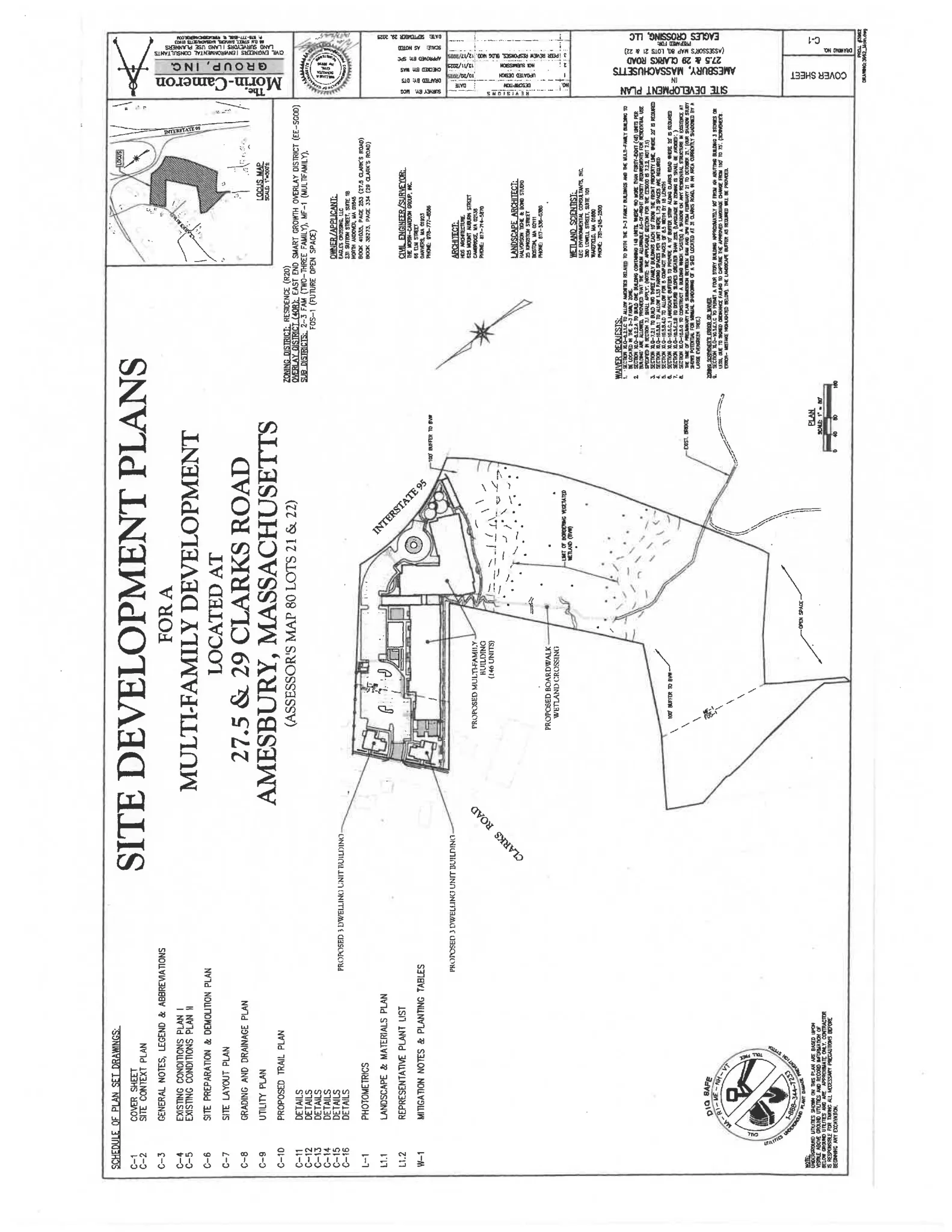
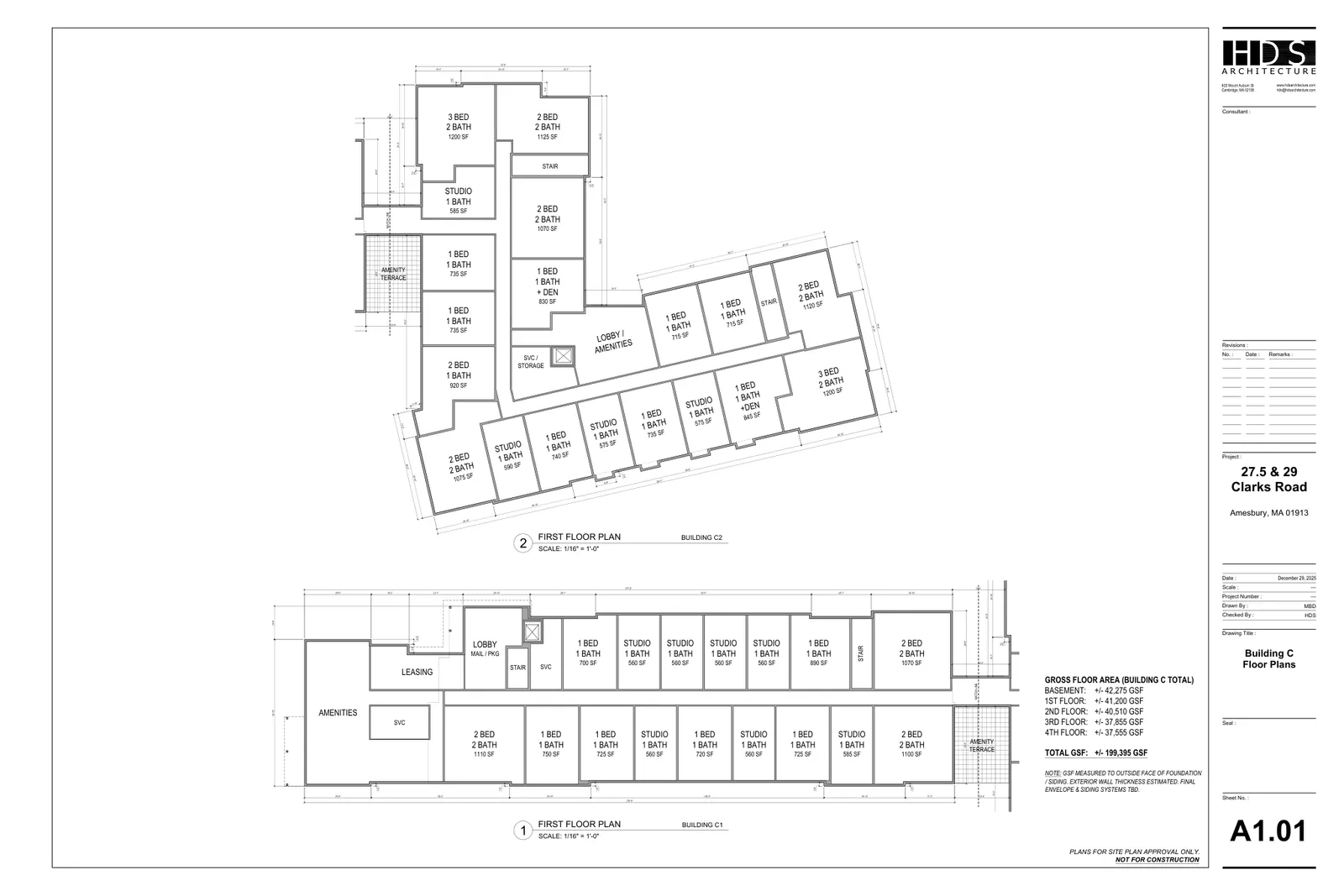
Eagles Crossing LLC applied for Site Plan Review to develop three residential buildings at 27.5 & 29 Clarks Road under the East End Smart Growth Overlay District. The proposal calls for 152 dwelling units distributed as 41 studios, 62 one‑bed units, 37 two‑bed units and 12 three‑bed units. The submitted materials include site development plans, landscape and architectural drawings, a stormwater management report, a Traffic Impact Assessment, and an Environmental Impact Report (EIR).
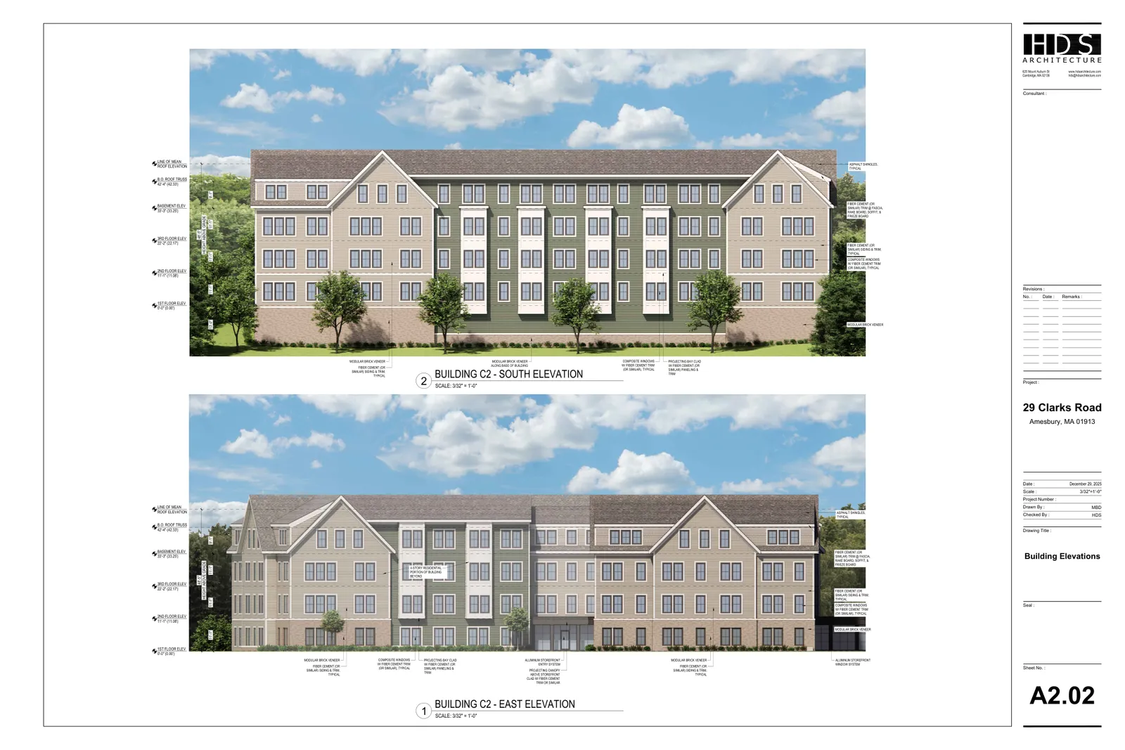
The submission shows two smaller two‑story buildings facing Clarks Road and a larger multifamily building behind them. Architectural drawings depict building materials and details such as fiber‑cement siding (or similar), thin brick veneer at selected elements, asphalt shingle roofs (with metal roof elements shown in places), composite windows, and typical residential scale trim and canopies. The multifamily building includes below‑grade parking beneath much of the structure.
Where and how big
The site is an approximately 10.87–11.0 acre parcel located on the southeast side of Clarks Road (south of Route 110 and northwest of I‑95). Existing improvements include two single‑family houses on the northern portion of the property; the central and southern portions are wooded upland and forested wetland.
The applicant’s Environmental Impact Report describes roughly 156,000 square feet of building area across the proposed development. The architectural plan set contains detailed gross floor area figures for each building and floor (for example, the set shows per‑building and per‑floor gross square footage and detailed floor plans for Buildings A, B and C). The proposal preserves about 7.1 acres (about 65% of the parcel) as open space/conservation land while concentrating buildings, parking and most site work in the northern part of the parcel.
Parking, access and transportation
The project proposes 203 parking spaces, including an underground/below‑grade garage beneath the multifamily building and surface parking elsewhere on the site. The applicant requested a waiver from the Smart Growth overlay parking standard to allow an overall parking ratio of about 1.33 spaces per unit (the submission and waiver materials reference industry parking generation guidance and the unit mix as the basis for the proposed supply). The application also requests permission for a number of compact parking spaces and other parking‑dimension waivers.
Primary vehicle access is shown from Clarks Road. Civil plans include a ramp down to the below‑grade parking and a retaining wall at the ramp location (the plan set indicates a wall of up to about 11 feet at the garage ramp area). The applicant submitted a Transportation Impact Assessment and the project was the subject of transportation peer review; the Planning Board record notes peer review comments that the applicant needs to address and that DPW must approve any off‑site improvements and final utility tie‑ins.
Wetlands, open space, stormwater and the proposed trail
A central forested wetland and braided intermittent stream cross the site. The applicant has filed a Notice of Intent (NOI) with the Amesbury Conservation Commission to obtain an Order of Conditions under the Massachusetts Wetlands Protection Act; that permit was pending at the time of the Planning Board decision.
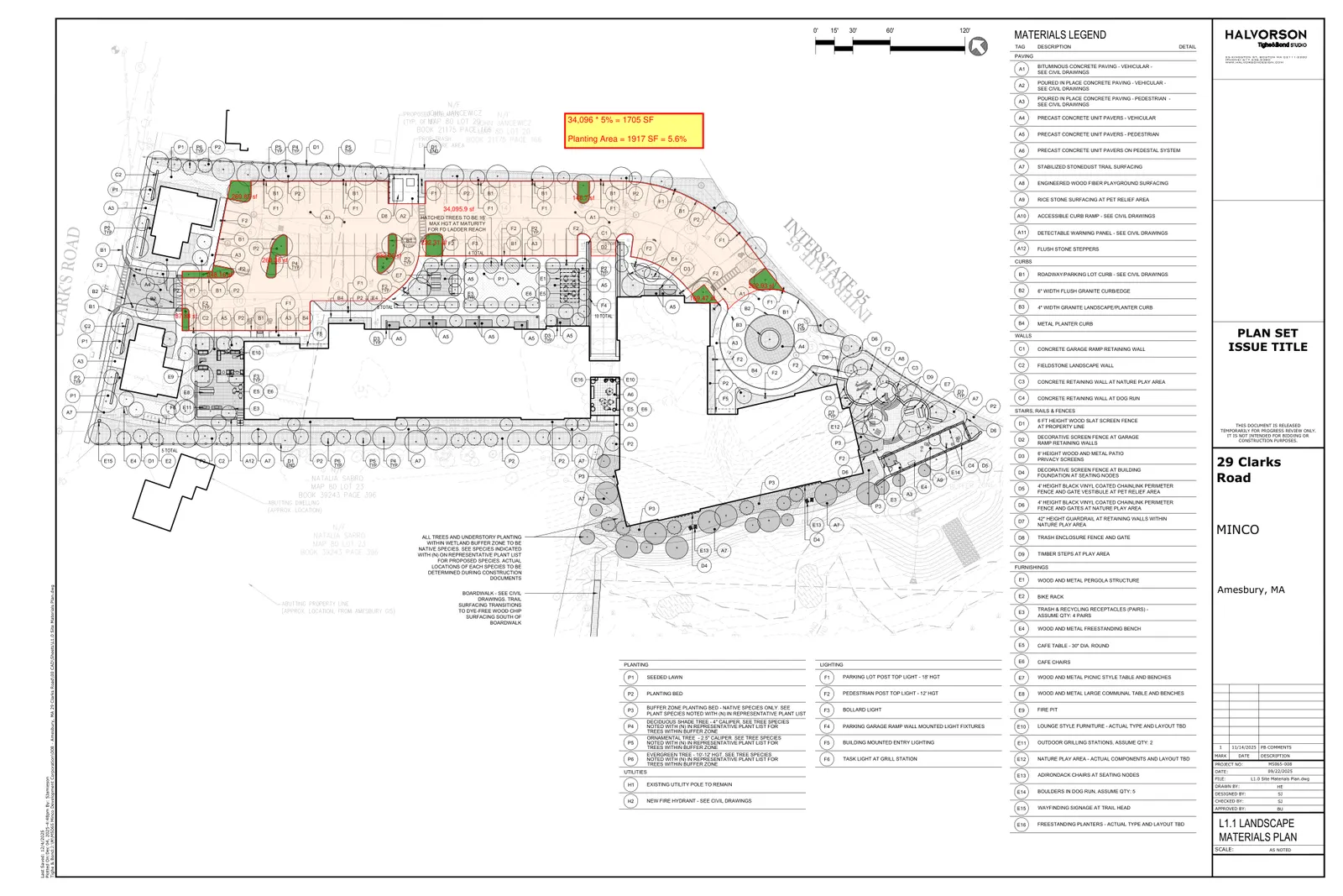
The proposal includes a five‑foot‑wide public recreational trail that uses a stone‑dust/mulch approach and a wooden boardwalk to cross the wetland and connect to existing trails off Point Shore Drive. Plans show the boardwalk supported on 4"x4" wooden posts mounted on helical piers, elevated a minimum of 12 inches over the wetland with 1/4"–3/8" gaps between decking boards. The boardwalk will span two stream channels and the plan identifies a small permanent wetland footprint for the posts (the EIR states about 10 square feet of permanent footprint) and a corresponding wetland replication mitigation area (a 2:1 replacement ratio is described in the wetlands materials). The trail alignment passes through portions of the wetland buffer areas and the submission identifies mitigation plantings (native trees and shrubs) to offset buffer zone impacts.
Stormwater management is shown as an integrated system of catch basins, pipes, proprietary treatment devices, underground infiltration chambers, and above‑ground basins intended to capture, treat and infiltrate runoff and to meet Massachusetts Stormwater Standards and the City of Amesbury Stormwater Management Ordinance. The submission includes drainage calculations, TSS removal documentation, pipe sizing and groundwater mounding analyses. Planning Board materials and the engineering peer review identify technical items that must be verified and incorporated into final construction drawings.
Permits, waivers, conditions and current status
The Planning Board held a public hearing that opened November 3, 2025 and closed January 29, 2026. The Board issued a final Site Plan decision on January 29, 2026; that decision records the application materials, findings, requested waivers, and lists conditions and required submittals.
Significant waiver requests submitted by the applicant include: allowing a single building to contain the majority of units (requests related to the ordinance limit on units per building), reducing the required parking ratio, allowing compact parking spaces, reducing the landscape buffer width along Clarks Road, permitting retaining walls greater than 6 feet, permitting some disturbance of slopes greater than 25%, and other dimensional/design waivers. The Planning Board decision and the applicant’s waiver submittal document these requests for the Board’s consideration.
The Board’s decision identifies a number of items that must be submitted or resolved before building permits issue or before construction proceeds. These items include (but are not limited to): retaining wall structural and geotechnical design; an ANR plan or equivalent lot‑line documentation if needed; finalized Affordable Housing Restriction and Marketing Plan components required under the Smart Growth overlay provisions; final deeds/easements and legal documents for open space and trail access; exact location, quantity and sizes of accessible units; utility capacity confirmation and DPW coordination; final architectural drawings for design compliance; and any changes required by the Conservation Commission’s forthcoming Order of Conditions. The decision also references engineering and transportation peer review comments that must be addressed.
A couple of permitting terms used in the record explained in plain language: a Notice of Intent (NOI) is the formal wetlands filing submitted to the local Conservation Commission to start review under the Massachusetts Wetlands Protection Act; an Order of Conditions is the permit the Conservation Commission issues after reviewing the NOI and it will specify what wetland work is allowed and what mitigation or changes are required. The Planning Board decision requires that any changes required by the Conservation Commission be submitted to the Planning Board to verify continued compliance with the Site Plan decision.
If you would like, I can prepare a short neighbor‑focused FAQ (covering parking, likely construction staging steps visible from the street, the trail route and wetland protections), or a plain timeline of the remaining permit steps needed before construction can begin.
Discussion at meetings
- AMENDMake a minor modification to the approved decision for 27.5-29 Clarks Road by striking the language referencing the existing utility pole across from Clarks Road and the east driveway in condition 17.
- CONTINUEI make a motion to continue this to February 23rd
- APPROVEI'll make a motion that we approve the decision as drafted and amended.
- CONTINUEto continue 27 and a half and 29 Clarks Road to the meeting of January 26th
- CONTINUEI would make a motion that we continue 27 and a half and 29 Clarks Road site plan to the January 12th meeting
- CONTINUEI make a motion to continue 27 and a half 29 Clark's Road site plan review until December 22nd
- OTHERSo I'll make a motion that we hire VHP to do the traffic study and the stormwater review, peer review, on behalf of the board and the city.
- CONTINUEI'd like to make a motion to continue the public hearing on 27 and a half 29 Clarks Road until December 8th
Documents on file


