
15 Cedar St - Request for Determination
Stormwater and drainage upgrades at the Lofts at Clarks Pond (25 Cedar St.) including roof drain reconfiguration, new pipe tie‑ins, curb removal and a crushed‑stone infiltration trench; the Conservation Commission determined the work is within the Buffer Zone and requires a Notice of Intent.

AI summary
The Lofts at Clarks Pond (25 Cedar St.) submitted an RDA to propose stormwater and drainage upgrades including roof drain reconfiguration, new 8"/6" drainage pipe runs, capping an existing outlet to R Street, removal of granite curb at the southern parking entrance, and installation of a crushed‑stone infiltration trench (~3' x 40' x 24"). The Amesbury Conservation Commission determined the work is within the Buffer Zone and requires filing of a Notice of Intent; an Order of Conditions (a wetlands permit) will be required before work in jurisdictional areas can proceed.
Gallery
Project details
What is proposed
The project is a set of stormwater management and drainage improvements for the Lofts at Clarks Pond condominium complex located at 25 Cedar Street (with associated parcels at 15 Cedar Street and 9 R Street) in Amesbury. The work was submitted as a Request for Determination of Applicability (RDA) and is intended to reduce flooding that was observed near the westerly residential building during multiple storm events in 2023 and to limit stormwater run‑on from adjacent roadways into the southern parking lot.
The primary elements described in the submittal are reconfiguration of the westerly building’s roof drainage system, installation of new underground drainage piping and connections to existing manholes, capping an existing pipe that discharged to R Street, selective removal and reinstallation of pavers where pipe work is needed, removal of granite curbing along the southern parking‑lot entrance, and construction of a crushed‑stone/infiltration trench at the pavement edge to promote sheet flow and infiltration toward the existing vegetated area that drains to the Back River.
Where and how big
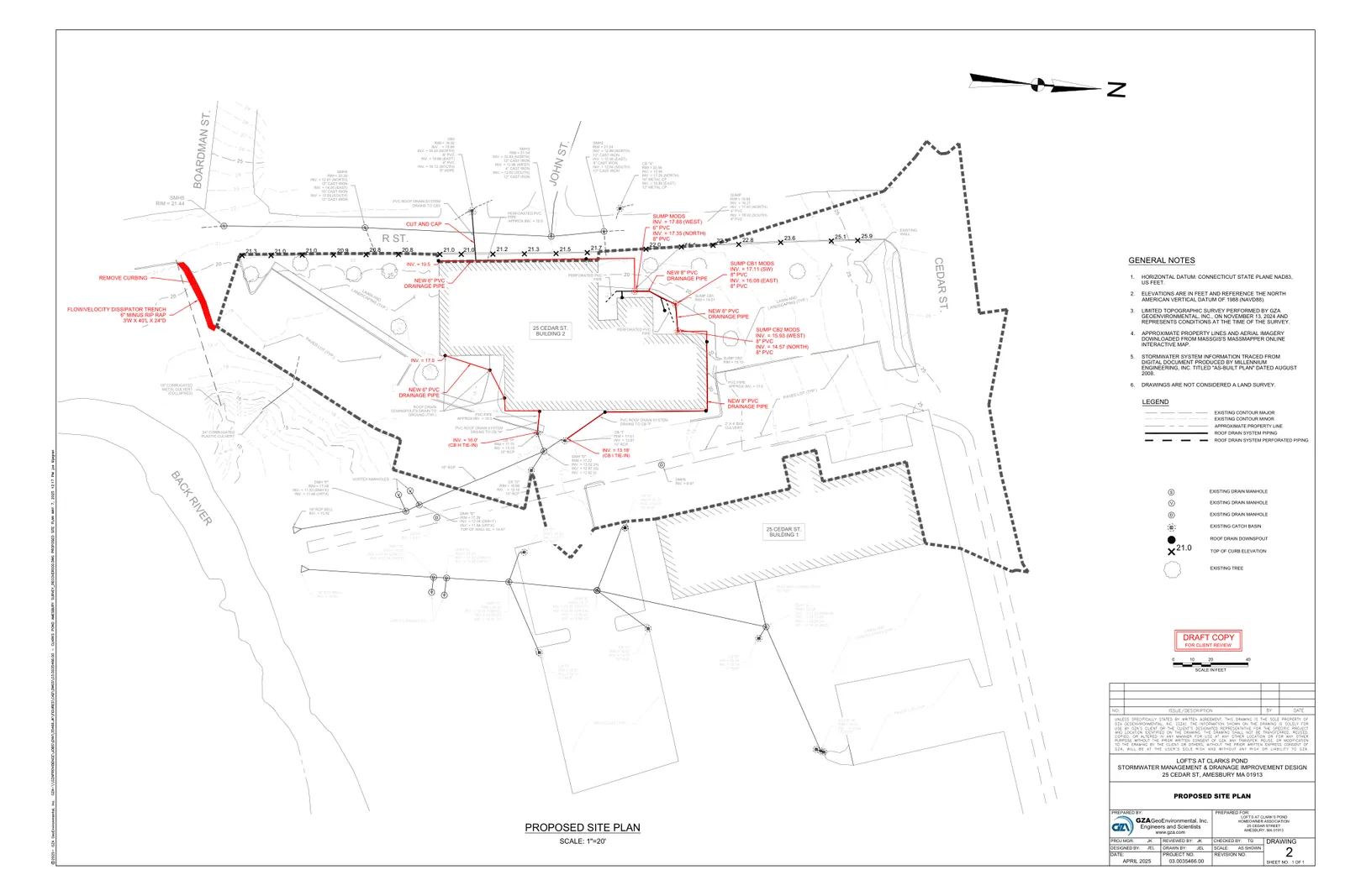
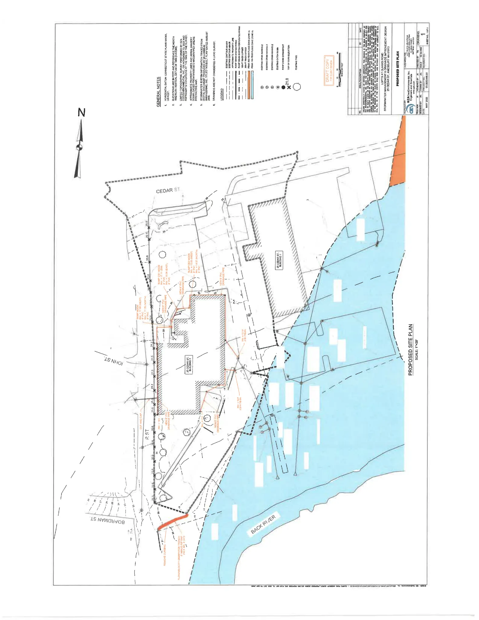
The work is located on parcels shown as Assessor Map 40, Lots 236, 237, and 238 (primary addresses 25 & 15 Cedar Street and 9 R Street). The submitted concept site plan (GZA, April/May 2025) shows two residential buildings, the paved parking areas, existing catch basins and manholes, contours, and the adjacent Back River. The plan locates the new pipe alignments and the curb removal/infiltration trench at the southern parking‑lot entrance along R Street.
A specific trench detail on the plan indicates a flow/velocity dissipator trench approximately 3 feet wide by 40 feet long by 24 inches deep. New underground pipe runs are sized on the plan and narrative as 8‑inch and 6‑inch drainage pipes in locations routed to tie into the existing stormwater management system in the eastern parking lot; roof drain piping and perforated pipe locations are also shown. The conceptual design was sized using a 100‑year, 24‑hour storm event for hydraulic modeling.
Materials and construction details
Roof drainage: existing roof drain PVC piping will be removed and downspouts/piping reconfigured so roof runoff is routed to the upgraded collection system.
New drainage piping: the narrative references installation of 8‑inch corrugated HDPE drainage pipe and the plan labels new 8" and 6" PVC drainage runs and some perforated PVC roof drain lines; the plan shows proposed trench alignments and tie‑ins to existing catch basins and manholes in the eastern/southern parking area.
Trench work and tie‑ins: trench excavation and backfill will be performed for pipe installation, with connections to existing manhole structures and capping of a pipe that previously discharged to R Street.
Curb removal and infiltration trench: removal of granite curbing along the southern shoulder of the southern parking entrance is proposed, with installation of a crushed‑stone trench along the pavement interface so stormwater can sheet off the pavement and infiltrate into the downgradient vegetated area. The plan shows small rip‑rap/energy dissipation detail at outfall locations.
Site impacts: proposed work is localized to paved lot edges, a northwest paved area by the westerly building, and the southern parking entrance; no changes to building footprints or new access roads are proposed.
Parking, access and transportation
Work is limited to parking‑lot edges, localized trenching, and curb/paver adjustments. The curb removal at the southern parking entrance is intended to allow stormwater coming from R Street, Boardman Street, and John Street to flow onto the shoulder and into the infiltration trench rather than pond on the pavement. The applicant identified winter icing of the southern parking lot as a safety concern; the proposed measures are intended to reduce standing water and ice accumulation in that area. The submitted materials do not propose changes to parking counts, building access, or vehicular circulation beyond the curb removal and trench placement.
Environmental and regulatory considerations
The site borders the Back River and includes areas within the State Riverfront Area and the local Amesbury Wetland Ordinance. The project was submitted to the Conservation Commission as an RDA under the Massachusetts Wetlands Protection Act (M.G.L. c.131, §40). The Conservation Commission issued a Determination of Applicability finding the proposed work is within the Buffer Zone and will alter an area subject to jurisdiction under the Wetlands Protection Act; the Determination indicates that the applicant must file a Notice of Intent (NOI) for the work.
Definitions of key technical terms used in the review process:
Request for Determination of Applicability (RDA): an application asking the Conservation Commission to determine whether proposed work is subject to the Wetlands Protection Act and whether additional filings are required.
Notice of Intent (NOI): a formal application that must be submitted when work will remove, fill, dredge or alter an area subject to the Wetlands Protection Act; the NOI is reviewed by the Conservation Commission and may lead to an Order of Conditions.
Order of Conditions: the Commission’s decision document (a wetlands permit) that sets the conditions under which proposed work in jurisdictional areas may proceed; work within jurisdiction cannot begin until a final Order of Conditions is issued.
The Determination also indicates municipal bylaws apply (Amesbury Wetland Ordinance), and that Riverfront Area alternatives considerations apply for any NOI filing as required by the state regulations.
Status and next steps
Materials submitted with the RDA included the WPA Form 1, the GZA project narrative and concept site plan (April/May 2025), a certified abutter list, certified mail receipts, and a legal advertisement. The applicant used MassDEP’s eDEP system for at least one submission (receipt information is included in the submittals).
The Conservation Commission’s Determination requires the applicant to file a Notice of Intent; the NOI must include detailed construction plans, any required alternatives analysis for Riverfront Area work, and supporting materials for public review. After the NOI is filed and the public hearing process is completed, the Commission would issue an Order of Conditions (the wetlands permit) that must be obtained before construction within jurisdictional areas may proceed.
For more detail or to review submitted documents, contact the City of Amesbury Conservation Commission or the project representative listed on the submission: Jaclyn Kaehler, P.E., GZA GeoEnvironmental, Inc., jaclyn.kaehler@gza.com, (401) 408‑1990.
Discussion at meetings
- APPROVEApprove NOI and issue Order of Conditions for 15 Cedar Street (DEP 002-1351)
- OTHERClose the hearing for the 15 Cedar Street NOI
- APPROVEA motion to issue a Positive Determination for RDA 15 Cedar Street.
Documents on file


