
66B Lake Attitash Rd - Certificate of Compliance
The Sherwoods received ZBA approval to add a second floor and enlarge the rear deck at 66B Lake Attitash Road, a pre‑existing non‑conforming single‑family lot in the R‑20 district.

AI summary
David and Victoria Sherwood received ZBA approval to add a second floor and enlarge the rear deck at 66B Lake Attitash Road, a pre‑existing non‑conforming single‑family property in the R‑20 district. The lot is 4,125 sq ft with limited frontage and the approved work increases the building to two stories and raises the roof height to about 30.54 ft; the Conservation Commission record includes wetland and floodplain considerations and a Certificate of Compliance matter is on file.
Gallery
Project details
What is proposed
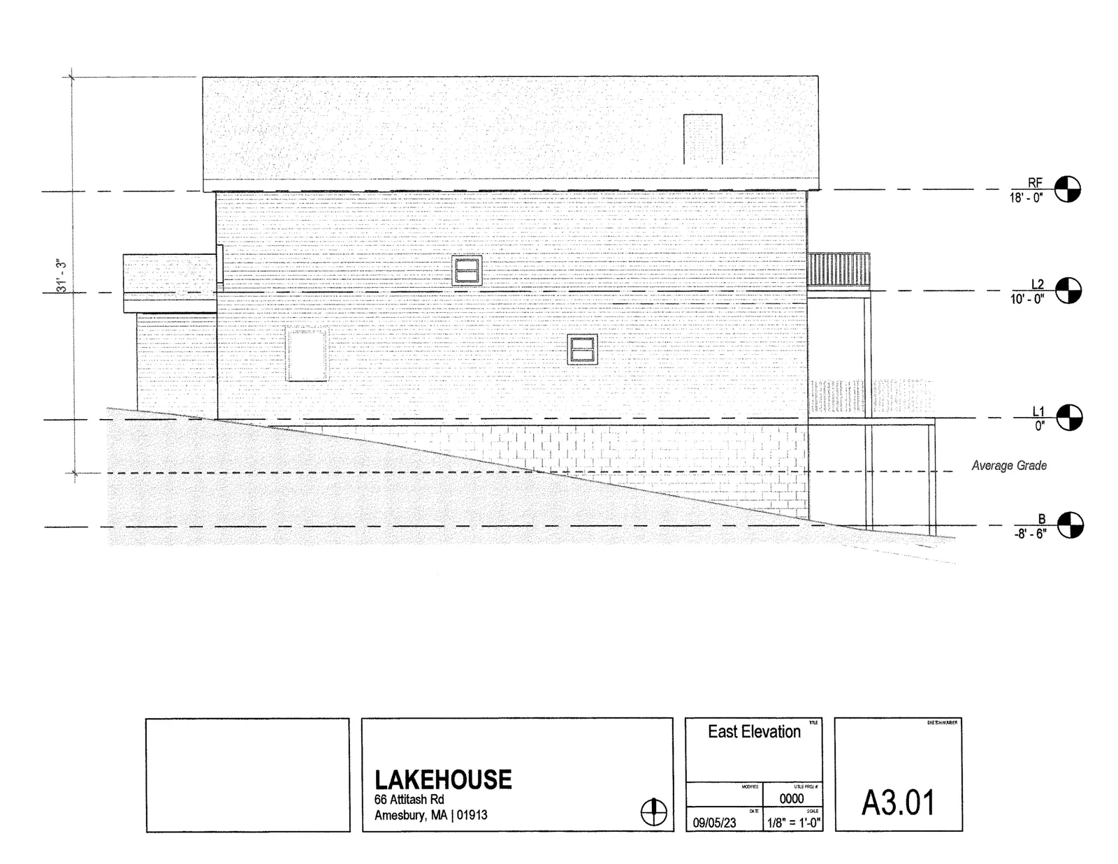
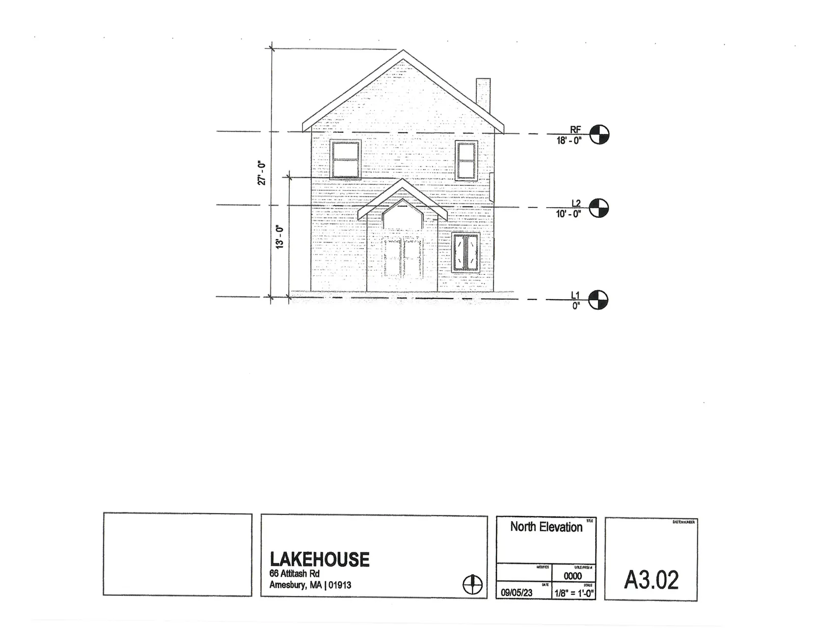
The applicants, David and Victoria Sherwood, propose to add a full second floor to the existing single‑family house at 66B Lake Attitash Road and to enlarge the rear deck. The submitted plans show raising the roofline to create a two‑story residence and increasing the deck footprint and deck height.
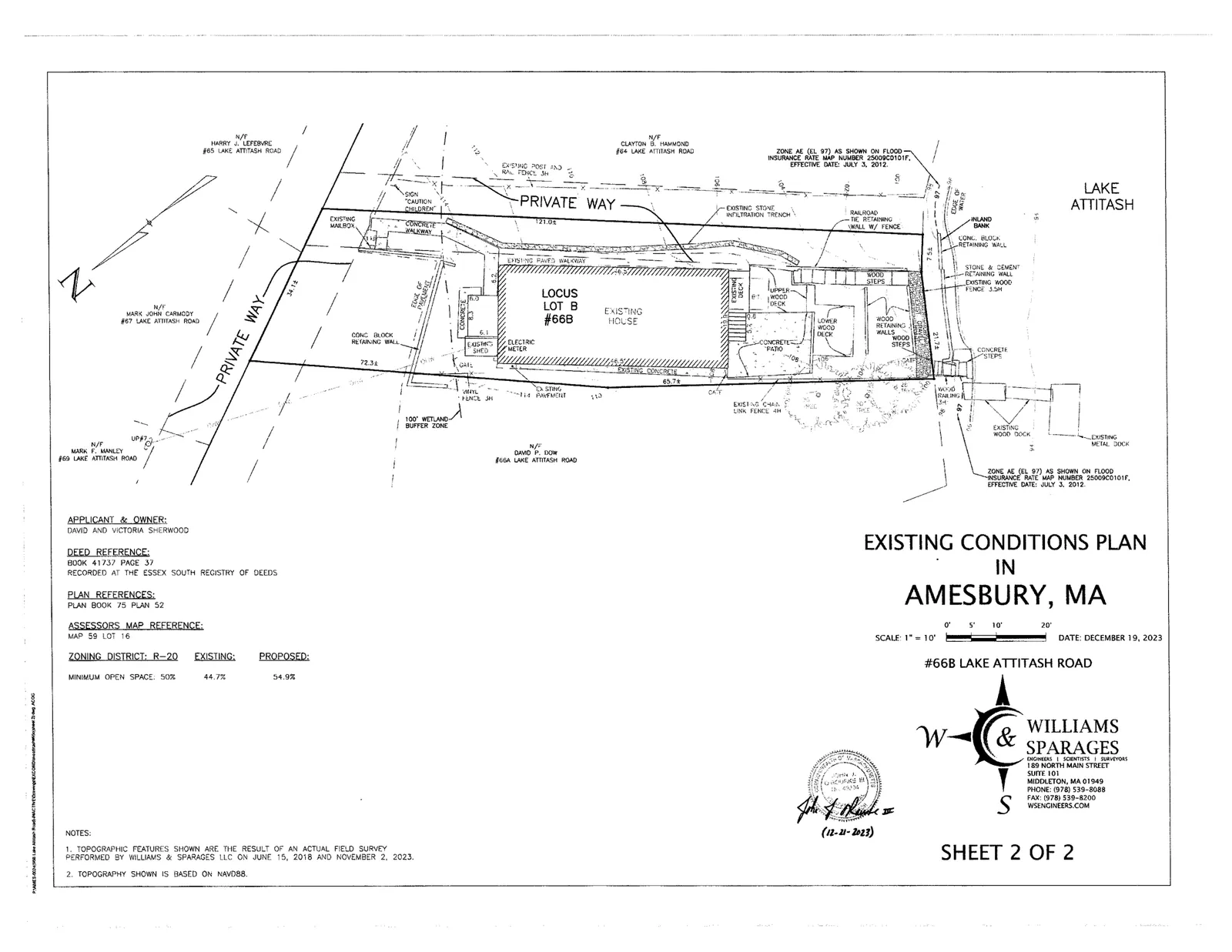
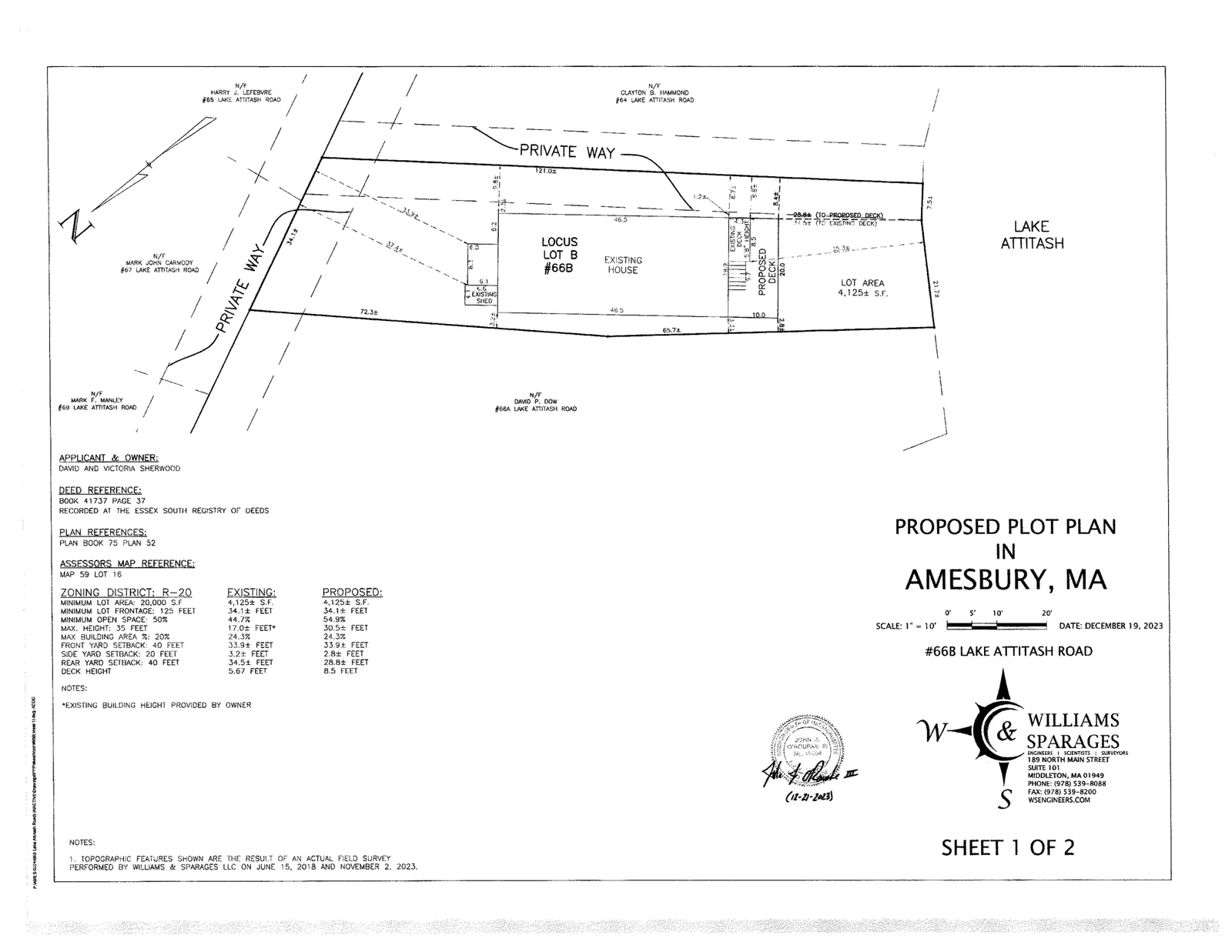
The application package includes site plans, floor plans and elevation drawings that depict the building massing, windows, balconies and roof geometry.
Where and how big
The property is located at 66B Lake Attitash Road in Amesbury’s R‑20 Residential zoning district (Assessor map 59, lot 16). Key dimensions shown on the plans include a lot area of 4,125 square feet, frontage of 34.14 feet, and an existing building area equal to 24.3% of the lot. The application lists the existing house as one story with a height of 17.0 feet and the proposed condition as two stories with a height of 30.54 feet.
Because the lot and structure pre‑date current zoning standards, the property is legally non‑conforming with respect to minimum lot area (R‑20 minimum 20,000 sq ft), minimum frontage (R‑20 minimum 125 ft) and certain yard setbacks. Selected setback figures shown on the plans are: front approximately 33.9 feet; rear 34.54 feet existing to 28.84 feet proposed; right side 3.2 feet existing to 2.8 feet proposed. Deck height is shown increasing from about 5.67 feet to about 8.5 feet.
The application materials indicate the house was built circa 1900 and the lot was created in 1956.
Parking, access and transportation
The project does not propose a change of use or additional dwelling units; it remains a single‑family residence. The submitted plans do not show changes to the driveway location or new off‑street parking areas. Access to the lot is from Lake Attitash Road (noted as a private way on the plans). The application does not include proposed modifications to public roads, curb cuts, or transportation infrastructure.
Environmental and regulatory considerations
The site plans identify nearby wetland resource areas and buffer zones adjacent to the property. The plans annotate features such as retaining walls and an infiltration trench. FEMA flood information is noted on the plans: the property is shown within Flood Zone AE on FEMA FIRM 25009C0101F (effective July 3, 2012). Flood Zone AE indicates an area with a mapped base flood elevation (1% annual chance flood).
Explanation of terms: a Certificate of Compliance is a statement issued by a municipal Conservation Commission confirming that work allowed under an Order of Conditions (the wetlands permit issued under the Massachusetts Wetlands Protection Act) has been completed in accordance with that Order. An Order of Conditions is the permit the Commission issues; a Certificate of Compliance is issued afterward to confirm compliance with that permit.
Because the project is adjacent to mapped wetland resources and in a mapped flood zone, the Conservation Commission will review the record and any relevant Orders of Conditions when considering a Certificate of Compliance.
Status and next steps
Zoning Board of Appeals: The Amesbury Zoning Board of Appeals held a public hearing on January 25, 2024 and approved the Special Permit / Finding under Section IX.B (case ZBAS‑23‑7) by a 4‑0 vote, allowing the addition of a second floor and enlargement of the rear deck on the pre‑existing non‑conforming structure. The ZBA decision notes the approval must be recorded at the Essex County Registry of Deeds and that the approval expires two years from the decision date (January 25, 2026) if not acted upon.
Conservation Commission: The project record notes an application or matter with the Conservation Commission for a Certificate of Compliance under the name Sherwood. The Conservation Commission will review the submitted plans, resource area mapping and any prior Orders of Conditions or enforcement history to determine whether a Certificate of Compliance can be issued.
For copies of the full decision, stamped plans, deed references or to confirm current Conservation Commission status and meeting dates, contact the Amesbury Municipal Development / Inspectional Services office or the Amesbury Conservation Commission. The ZBA decision references the recorded deed in the Essex County Registry (Book 41737, Page 37).
Discussion at meetings
- APPROVEI'm open to a motion to issue the certificate of compliance.
- APPROVEIssue COC 002-1220 66B Lake Attitash Road
- APPROVEApprove NOI and issue OOC 002-1323 66B Lake Attitash Road


