
89 Powow St - Modification
Modification application to install State Police/Motorola antennas and related equipment on the existing 180-foot self-support tower at 89 Powow Street; structural analysis reports the tower can carry the proposed loading.

AI summary
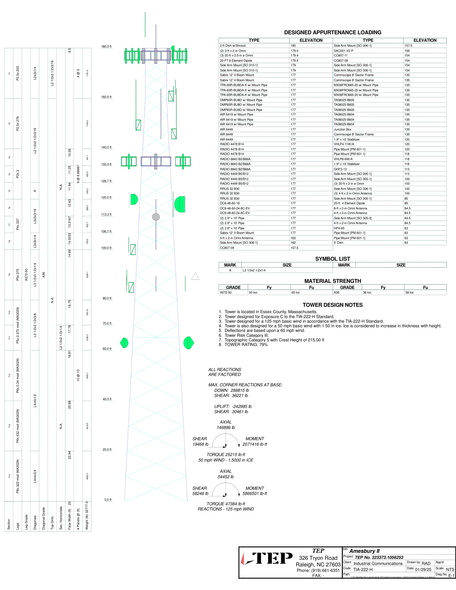
A modification application to add State Police / Motorola antennas, microwave dishes and related equipment to the existing 180-foot self-support tower at 89 Powow Street. Construction drawings (Airosmith Engineering) and a structural analysis (TEP) accompany the submission; TEP reports a structure rating of 79% and concludes the tower and foundation can support the analyzed loads. The design team has submitted an Initial Construction Control Document and a pre-application letter; final permitting will proceed through local building and planning review.
Gallery
Project details
What is proposed
The project proposes upgrades to the existing CoMIRS public safety radio installation at 89 Powow Street. The work shown on the submitted construction drawings consists of installing State Police / Motorola antennas and microwave dishes on the existing 180-foot self-supporting tower, adding related feedlines and mounts, and upgrading site equipment inside the fenced compound (equipment shelter, standby generator and associated foundations and utilities).
The drawings identify individual appurtenances by manufacturer and model (examples: RFI CC807-09 and CC807-11 omni antennas; Commscope VHLP4-11W and VHLP6-6W microwave dishes; Filtronic SAC001-V2-P TTA) and show feedline sizes (examples: 7/8" coax, 1/2" coax). Appurtenance is the technical term for equipment attached to the tower (antennas, dishes, mounts and feedlines). CoMIRS refers to the Commonwealth’s public safety radio system.
Where and how big
The site is identified as "Amesbury - Pow Wow Hill II" at 89 Powow Street, Amesbury, MA (latitude 42° 51' 56.5" N, longitude 70° 56' 12.6" W). The tower base elevation is shown near 313 feet mean sea level and the tower height is about 180 feet above ground.
The construction drawings show proposed antenna centerlines clustered in the upper portions of the tower (examples include centerlines in the 154–163 foot AGL range and microwave dishes near 118–120 foot AGL). The compound plan shows the fenced area, equipment shelter location and foundations, generator and propane tank foundations, conduit routes, and surfacing/trench details.
Equipment and engineering details
The construction drawings were prepared by Airosmith Engineering (dated 03/25/2025) and reference applicable codes and standards including ANSI/TIA-222-H (tower structural standard) and the Massachusetts State Building Code. A structural analysis performed by TEP (dated 01/29/2025) modeled the existing plus proposed and reserved loading and reports a structure rating of 79.0% (the highest member utilization used in the analysis) and foundation/soil interaction utilization reported at 36.4%. The TEP report concludes the tower and foundation, under the assumptions and loading listed in the report, have sufficient capacity and that no structural modifications were required for the analyzed load case.
The Initial Construction Control Document (dated 03/28/2025) was submitted by the registered design professional for the project (Joseph Johnston, MA Reg. No. 50391). That document states the design professional will provide construction-period services and site presence as required by the Massachusetts building code; this document is typically submitted with a building permit application.
Technical terms explained: A structural analysis is engineering work that calculates whether the existing tower and foundation can safely support the weight and wind/ice loads of existing and new equipment; AGL means "above ground level" and indicates the mounting elevation of antennas on the tower.
Site features, access and safety measures
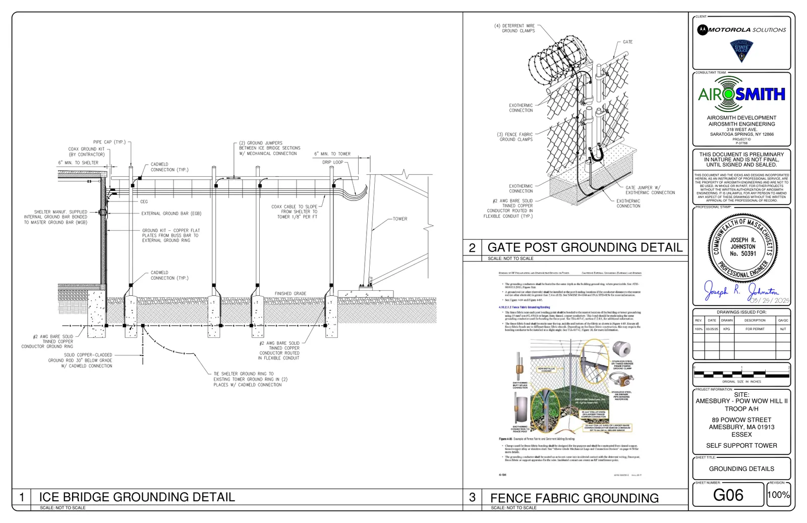
The drawings depict a secured, fenced compound with an access gate and site security-camera details. Grounding plans include ground rods and a ground ring, and the drawings show grounding details for the tower, compound fence and shelter equipment. Utility and conduit routing plans, generator trench and surfacing details, and foundation details for the equipment shelter (with alternate details for bedrock or non-bedrock conditions) are included.
The documents state the facility is unmanned (no human habitation at the site) and that technicians will visit for maintenance. Construction notes require contractors to verify existing site conditions and to control typical construction impacts (such as trash disposal and erosion/disturbance controls).
Status and next steps
Items on file with the City include the Airosmith construction drawings (03/25/2025 revision 100), the TEP structural analysis report (01/29/2025), the Initial Construction Control Document (03/28/2025), and a pre-application cover letter (04/29/2025) submitted for a State Police / Motorola antenna installation. The application type recorded for Planning Board review is a "Modification" and the listed applicant/property owner is Industrial Tower and Wireless LLC.
Next procedural steps for the applicant typically include submitting the full building-permit application and construction-control documentation to the building official, who will require construction-period oversight per 780 CMR (the Massachusetts State Building Code). The TEP structural analysis recommends re-evaluation if the actual installed equipment or loads differ from those analyzed in the report.
Discussion at meetings
- OTHERDetermine the proposal for 89 Powwow St. was a minor modification.
- APPROVEApprove the minor modification at 89 Powwow St. with the conditions outlined (provide written Fire Department approval; verify noise levels comply with ordinance at the property line; return to Board if standards exceeded).


